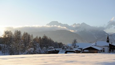
This winter walk along the foot of the Mieming Mountains offers fabulous views of the Stubai Alps, leading through forests, moorland, a golf course and two huts serving food and drink. It is relatively long at 10km, but it is still good for families with children thanks to its flat profile and wide paths. Along the way there is a playground in the forest and the chance to replenish all those calories burned with a hearty meal at the Stöttlalm hut or the Moosalm hut.

Winter Hike
Starting point
Lehnbach car park, Obermieming
Finishing point
Lehnbach car park, Obermieming
Mountain chain
Mieming Mountains
Length
10.1 km
Total hiking time
2 h 45 min
Features
- Circular hike
Difficulty rating
easy
Altitude
Elevation uphill 125m
Vertical metres downhill 125m
Fitness level
Technique
Best time of year
* These are approximate values and recommendations. Please take your personal fitness level, technical ability and the current weather conditions into account. Tirol Werbung cannot guarantee that the information provided is correct and accepts no liability.
Parking
Lehnbach car park, Obermieming
Places serving food & drink
- Stöttlalm
- Moosalm
Downloads
Trail description
From the Lehnbach car park in Obermieming, follow the trail leading gently uphill via the golf course to the Stöttlalm hut (980 metres). This is a good place for an early stop to enjoy a snack and drink in the views of the sunny Mieming Plateau all the way to the Stubai Alps. From the hut, take the winter walking trail in a southerly direction and, after just a few minutes, cross the Judenbach stream and then the Stöttlbach stream using the new bridge. Follow trail 12B heading south (follow the signs for "Moosalm") and then turn right onto the "Sonnenplateau-Rundweg" trail, which leads through a relatively long section of forest. Near the settlement of Bibersee you will pass a forest play area and then reach an area of moorland. Head anticlockwise through the meadows, which are also popular with cross-country skiers in winter, and then stop off at the Moosalm hut in Barwies. From there, return along the same route back towards the car park, but at the end of the forest take the trail right to the settlement of Lehnrain and the bridge over the Lehnbach stream.


