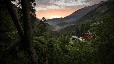
The Spitzsteinhaus (1,252 metres) is a mountain hut popular with hikers in summer and ski touring enthusiasts in winter. It is located in the Chiemgau Alps and is open all year round.
Mountain hut on the craggy Spitzstein peak
German Alpine Club, Bergfreunde München Division
Lush meadows, thick forests, hikes for all abilities: the Spitzsteinhaus in the Chiemgau Alps is an excellent base for exploring the surrounding region. This hut near the Bavarian border welcomes families and groups all year round – for walking and hiking in summer, and for ski touring and snowshoeing in winter. The area around the hut is generally safe from avalanches. The views are excellent and take in not only the town of Kufstein but also the Inn Valley and the Kaiser Mountains. The area around the Spitzstein mountain is also good for mountain biking. Food is served on the sunny terrace and produced using local ingredients. The hut, which sleeps up to 50 guests, has showers and mobile phone reception.
How to get to the hut
Frpm Erlerberg/Gasthof Moosbauer in 1.25 hours, from Goglalm car park in 20 minutes, from Innerwald in 2 hours, from Sachrang / village centre in 2 hours, from Hainbach via Klausenhütte in 4 hours
Walks and hikes in the area (walking time to summit)
Spitzstein (1,596 metres), 1.25 hours, intermediate (alternative northern climbing route: difficult)
Brandelberg (1,516 metres), 1.75 hours, intermediate
Zinnenberg (1,566 metres), 3 hours, intermediate
Hike around the Spitzstein mountain, 5 hours, intermediate
Further huts in the area, long-distance hiking trails
Hochrieshütte, 4.5 hours
Riesenhütte, 3.5 hours
Klausenhütte, 2.5 hours
The Spitzsteinhaus is located on the Via Alpina long-distance hiking trail.
Mountain hut on the craggy Spitzstein peak German Alpine Club, Bergfreunde München Division Lush meadows, thick forests, hikes for all…


