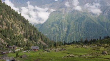
The Neue Regensburger Hütte (2,286 metres) is a very well-equipped German Alpine Club mountain refuge above the Falbesoner Ochsenalm in the Stubai Alps, Tirol.
Extremely well-equipped mountain refuge hut with swimming lake
German Alpine Club, Regensburg Division
On your way up to this hut, we strongly recommend stopping at the Falbesoner Ochsenalm and allowing your gaze to wander up to the ridge where the Neue Regensburger Hütte stands tall. A bubbling brook with a waterfall that plunges 300 metres down to the alpine meadows shows just how far you have left to go. Once there, the "Hohe Moos", a breathtakingly beautiful area of moorland which feeds the pleasantly warm swimming lake in front of the hut, opens up in front of you. The hut is very presentable in every respect, with three wood-panelled rooms where seminars can be held, spacious bedrooms, a wonderful sunny terrace and great food. The Neue Regensburger Hütte is located on the Stubai High Trail, and there is a rock climbing area nearby. Well-known nearby mountains: Kreuzspitze, Ruderhofspitze, Habicht, Östliche Seespitze, Westliche Seespitze, Vordere Plattenspitze.
How to get to the Neue Regensburger Hütte
From Neustift in Stubaital, leaving from the settlement of Falbeson (parking for the hut at the Waldcafé), via the Falbesoner Ochsenalm (2.5 to 3 hours).
Walks and hikes in the area (walking time to summit)
Falbesoner See, (2,580 metres), 1.25 hours, intermediate
Basslerjoch (2,829 metres), 2.25 hours, intermediate
Vordere Plattenspitze (2,935 metres), 2 hours, difficult
Kreuzspitze (3,080 metres), 2.5 hours, difficult
Ruderhofspitze (3,474 metres), 5.5 hours, difficult (glacier crossing)
Rock climbing area near the hut (routes rated between III and VII)
Further huts in the area, long-distance hiking trails
Dresdner Hütte, 6 hours
Franz-Senn-Hütte, 4 hours
The Neue Regensburger Hütte is located on the Stubai High Trail.
Extremely well-equipped mountain refuge hut with swimming lake German Alpine Club, Regensburg Division On your way up to this hut, we strongly…


