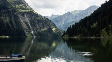
The Haldenseehaus (1,150 metres) lies in the Allgäu Alps and is a good base for hiking, skiing, mountian biking and rock climbing in the surrounding region.
Mountian hut in the Tannheimer Tal Valley with plenty of options
German Alpine Club, Hohenstaufen Göppingen Division
This basic but beautiful self-catering hut in the Tannheimer Tal is close enough to the nearby villages for visitors to buy provisions from the shops and carry them up to the accommodation, but at the same time far enough away from civilisation to offer total peace and quiet. Climbers will appreciate the routes on mountains such as the Rote Flüh and the Gimpel. The hut, which sleeps up to 90 people in a mix of rooms and dormitories, is a fine base for walkers, hikers and mountain bikers keen to explore. Indeed, with the Haldensee lake just a stone's throw away, you could even organise your own alpine triathlon! The Haldenseehaus is open all year and welcomes skiers and snowboarders in winter.
How to get to the hut
The Haldenseehaus is near the village of Nesselwängle and can be reached by car or using public transport.
Walks and hikes in the area (walking time to summit)
Krinnenspitze (2,000 metres), 3.25 hours, intermediate
Rote Flüh (2,108 metres), 3.5 hours, difficult
Gimpel (2,176 metres), 3.75 hours, difficult
Köllenspitze (2,240 metres), 4.25 hours, difficult
Nesselwängler Scharte (2,007 metres), 3.5 hours, intermediate
Further huts in the area
Landsberger Hütte, 4 hours
Otto-Mayr-Hütte, 3 hours
Bad Kissinger Hütte, 2 hours
Mountian hut in the Tannheimer Tal Valley with plenty of options German Alpine Club, Hohenstaufen Göppingen Division This basic but beautiful…


