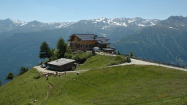
The Barmer Hütte (2,610 metres) is an alpine hut in the Rieserferner Massif. It offers walkers, hikers and mountaineers a good meal and a warm bed.
Alpine hut for hikes up to 3,000 metres above sea level
German Alpine Club, Barmen and Wuppertal Division
The Barmer Hütte is located at the foot of many mountains up to 3,000 metres high. Little wonder, then, that it is a popular base for walkers, hikers and mountaineers keen to explore the region. The trail to the hut leads through the Patscher Tal Valley and passes the ruins of the old Barmer Hütte constructed in 1900 but destroyed by an avalanche in 1956. Four years later, the Wuppertal Division of the German Alpine Club rebuilt the hut on the same spot. Today it is open from June until late September. In winter there is an emergency room. Most of the hikes and climbs around the hut are challenging.
How to get to the hut
From the Patscher Alm hut (intermediate) 3.25 hours, from the Antholzer See lake (intermediate) 3.75 hours, from the Staller Sattel ridge (intermediate) 4 hours
Walks and hikes in the area
Almerhorn (2,986 metres), 2 hours, intermediate
Rosshorn (3,068 metres), 2.5 hours, difficult
Lenkstein (3,236 metres), 3.5 hours, difficult
Große Ohrenspitze (3,101 metres), 2 hours, intermediate
Hochgall (3,435 metres), 3.5 hours, difficult
Barmer Spitze (3,200 metres), 3 hours, difficult
Further huts in the area, long-distance walking trails
Kasseler Hütte (Rif. Roma), 6 hours
Barmer Haus, 3 hours
The Barmer Hütte is located on the East Tirol 360° (Austria Skyline Trail).
Alpine hut for hikes up to 3,000 metres above sea level German Alpine Club, Barmen and Wuppertal Division The Barmer Hütte is located at the…


