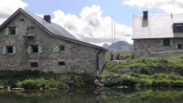
Measuring just under 15 kilometres in length, this hike leads through high alpine terrain to the Wiesbadener Hütte (2,443 metres) and offers fine views of the Piz Buin, at 3,312 metres the highest mountain in the Austrian province of Vorarlberg. The hut is a good base from which to climb the Piz Buin and other surronding peaks. This walk begins and ends at the Silvretta reservoir at Bielerhöhe (2,030 metres). All in all the hike of intermediate difficulty, though walkers will need good overall fitness and sure-footedness in high alpine terrain.


Mountain Hike
Starting point
Bielerhöhe / Galtür
Hike to
Wiesbadener Hütte
Finishing point
Bielerhöhe / Galtür
Mountain chain
Silvretta Alps
Length
14.8 km
Total hiking time
5 h 15 min
Features
- Wheelchair-accessible Hiking Route
- Circular hike
Difficulty rating
intermediate (red mountain trails)
Altitude
Elevation uphill 680m
Vertical metres downhill 680m
Fitness level
Technique
Best time of year
* These are approximate values and recommendations. Please take your personal fitness level, technical ability and the current weather conditions into account. Tirol Werbung cannot guarantee that the information provided is correct and accepts no liability.
Public transport
- Accessible using public transport
Bus route 260, get off at stop Bielerhöhe Silvrettasee
Parking
Parking available at Bielerhöhe (free for holders of the Silvretta Card)
Places serving food & drink
- Wiesbadener Hütte
- Alpengasthof Piz Buin
- Berggasthof Hotel Piz Buin
- Restaurant Silvrettasee auf der Bielerhöhe
Downloads
Trail description
The starting point of the hike, Bielerhöhe, can be easily reached by car or bus from Galtür. From here, the trail runs in a south-easterly direction along the Silvretta dam until a wide hiking trail branches off at a signpost branches left gently uphil into the Bieltal Valley. Follow this path to the stream and continue along a narrow hiking trail through the Bieltal Valley. This is followed by a serpentine ascent to the Radsattel at an altitude of 2,652 metres before descending again to the Wiesbadener Hütte. Here you will be able to see the Ochsental glacier, the Silvrettahorn (3,244 metres) and the Schneeglocke (3,223 metres). The view of the summit of Piz Buin is impressive, not least during a culinary refreshment on the sunny terrace outside the hut. Return to Bielerhöhe the way you came.
Important! There is a shuttle bus for hikers which runs between Landeck and Bielerhöhe.


