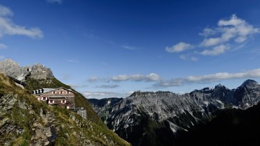
There are few better ways to spend a day in the mountains than on a hike to a charming hut on the shores of a lake. The Bremer Hütte is one of the most beautiful huts and an important base for hikers and climbers wishing to explore the surrounding peaks.

Mountain Hike
Starting point
Gasthof Feuerstein, Gschnitz
Hike to
Bremer Hütte
Finishing point
Gasthof Feuerstein, Gschnitz
Mountain chain
Stubai Alps
Length
16 km
Total hiking time
5 h 45 min
Features
- Wheelchair-accessible Hiking Route
- Circular hike
Difficulty rating
intermediate (red mountain trails)
Altitude
Elevation uphill 1,150m
Vertical metres downhill 1,150m
Fitness level
Technique
Best time of year
* These are approximate values and recommendations. Please take your personal fitness level, technical ability and the current weather conditions into account. Tirol Werbung cannot guarantee that the information provided is correct and accepts no liability.
Public transport
- Accessible using public transport
Bus route 4146, get off at stop Gschnitz Gh. Feuerstein
Parking
Car park next to the Gasthof Feuerstein, at the end of the tarmac road.
Trail description
The starting point for this relatively challenging hike in the eastern Stubai Alps is the car park right next to the Gasthof Feuerstein inn. The name of the inn is a reference to not one but two peaks in the surrounding area bearing the name Feuerstein, a striking double summit in the Stubai Alps. However, this hike "only" leads to the Bremer Hütte (2,413 metres) instead of taking on one or both of these summits. It is also a starting point on the Stubai High Trail and the Gschnitztal Circular Hike. Follow the wide access road to a bridge over the Gschnitzbach, where a footpath branches off to the left. This leads up to the Alpengasthof Laponesalm (1,472 metres). Shortly after the alpine inn, a narrow path leads to the right and climbs quite steeply up the northern slope of the valley towards the Bremer Hütte at the foot of the Innere Wetterspitze, first reaching the Obere Simmingalm. After crossing a stream, you walk left past the Simmingsee lake (2,010 metres), a wonderful natural gem. The path then leads over a striking rocky ridge and winds its way across the boulder terrain up to the Bremer Hütte (2,411 metres), where you can linger to enjoy the fine view of the panorama comprising many surrounding peaks and glaciers.
Return along the way you came.
Tip! The long approch into the valley along the road can be shortened by mountain bike or with the a taxi shuttle service from the Laponesalm. This saves you around 7 kilometres there and back and 235 vertical metres of climbing and descending.


