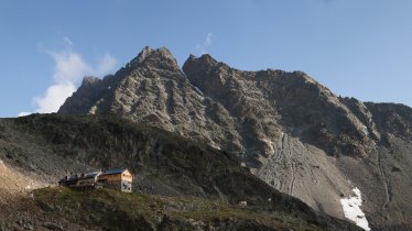
This mountain hike of intermediate difficulty takes in the 2,560m Hochzeiger peak. It begins with a walk into the Riegetal Valley, a side valley branching off the larger Pitztal Valley. This quiet and secluded region in the west of Tirol is a protected nature reserve and home to a rich variety of flora and fauna. Highlights include marmots, mountain salamanders, chamoix and sheep as well as many alpine flowers in bloom. The hike also passes the Groaßsee lake, one of the most beautiful mountain lakes in the Pitztal Valley, where the craggy peaks of the Wildgrat mountains are reflected on the water's surface.

Circular Hike
Starting point
Top station of Hochzeiger cable car, Jerzens
Hike to
Riegetal, Großsee, Hochzeiger
Finishing point
Top station of Hochzeiger cable car, Jerzens
Mountain chain
Ötztal Alps
Length
7.3 km
Total hiking time
5h
Features
- Wheelchair-accessible Hiking Route
- Circular hike
Difficulty rating
intermediate (red mountain trails)
Altitude
Elevation uphill 730m
Vertical metres downhill 720m
Fitness level
Technique
Best time of year
* These are approximate values and recommendations. Please take your personal fitness level, technical ability and the current weather conditions into account. Tirol Werbung cannot guarantee that the information provided is correct and accepts no liability.
Public transport
- Accessible using public transport
Bus route 4204, get off at stop Jerzens Hochzeiger
Parking
Car park at the bottom of the Hochzeiger cable car
Downloads
Trail description
This circular hike into the Riegetal Valley, a protected nature reserve, begins at the mid-way station of the Hochzeiger cable car. From there, hikers follow trail no. 12 towards Zollberg. From Zollberg the route continues along a narrow path, the "Goaßsteig", with several sections secured with ropes, down into the Riegetal Valley. Then the trail becomes easier and leads through the idyllic valley to the Großsee lake. After a rest next to the lake, the route leads back along the same route before branching off right onto a steeper trail leading towards the Hochzeiger mountain. At the peak of the Hochzeiger at 2,560 metres above sea level there is time to admire the view and write your name into the log book stored at the mighty cross atop the summit before descending along the easily visible trail leading down to the mid-way station of the Hochzeiger cable car.


