Arrival by public transport
Bus line J to the Hungerburgbahn valley station
The spectacular Hafelekarbahn cable car takes you up quite a bit, which is why you first hike almost flat along the Goetheweg. The view of Innsbruck is magnificent, but please pay attention to the path!
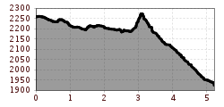
One of Innsbruck's most beautiful high-altitude tours for experienced mountain hikers: the ride up the Hafelekar with the Nordkettenbahnen cable car is spectacular and after the morning mist has lifted, the Goetheweg trail opens up a fantastic view of Innsbruck and the Inntal valley. An overnight stay at the cozy Pfeishütte is recommended. The outward and return route (total length just over 10 km, walking time approx. 4.5 hours) can also be completed in an ambitious day hike, but then you miss out on a night in a hut under the stars.

The Goetheweg trail starts right next to the Hafelekar mountain lift station and leads east along the ridge. After a few short ascents and descents, hikers come to the Mühlkarscharte where they cross the ridge and continue along the northern face to the Mandlscharte. After a short descent, the landscape changes. Alpine meadows and mountain pines form the backdrop for the last section to the Pfeishütte mountain hut. The hut is located over 1,900 metres above sea level in a pristine alpine setting with the rugged peaks of the Rumer Spitz, the Stempeljoch and the Bachofen rising up all around it.
The walking time from Hafelekar to the mountain hut is 2-2.5 hours (one way!). The walking time including the return journey to Hafelekar is approx. 4.5-5 hours. All other route options take considerably longer.
Return walk from the Pfeishütte mountain hut
Route option 1: Via the Goetheweg trail back to the Hafelekar or a bit further down to the Seegrube. The Nordkettenbahnen lifts to Innsbruck can be accessed from Hafelekar and from the Seegrube.
Route option 2: Anyone who would like to return a different way can take the route down from the Pfeishütte mountain hut via Kreuzjöchl. The route goes via Kreuzjöchl, the Vintlalm mountain hut and the Rumer Alm mountain hut and ends in the holiday village of Rum. There are buses from Rum to Innsbruck.
Route option 3: From the Pfeishütte mountain hut, along scree fields, up to the Stempeljoch and then down from the ridge. Without losing altitude, a trail branches off to the right into a widely spaced larch stand. The trail meets the road by the highest house in the Hall Valley and follows it to the former "Herrenhäuser"manor houses. It is possible to take a shortcut via the former salt mine huts. From the "Herrenhäuser", the trail turns right and continues down to St. Magdalena, an alpine guesthouse and former monastery nestled in the mountains. For anyone who doesn't want to continue on foot: at the weekend during hiking season, a shuttle bus runs from here to Absam every hour (fees apply). From Absam, it is possible to take a public bus to Innsbruck.
Bus line J to the Hungerburgbahn valley station
Car park valley station Hungerburgbahn