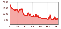
Lasting between six and eight days, this long-distance hike begins in Lech am Arlberg at 1,793 metres above sea level. It is well worth starting with a quick detour to the Formarinsee lake with its majestic views. The trail then leads from Steeg to Holzgau, past highlights including an impressive waterfall. From Stanzach onwards the Lech River Trail takes hikers along the gravel riverbanks characteristic of the Lech, one of Europe's last remaining untamed river landscapes.
Stage 1: Formarinsee – Lech
Uphill/downhill: 212/638 vertical metres, walking time: 5 hours, distance: 14 kilometres
Our journey through the Lech Valley begins at the Formarinsee lake and with it, of course, the “Lechweg” trail. Starting at the romantic location of the Formarinsee lake (1,793 metres) the first stage of this long-distance hiking trail leads along the banks of the Formarinbach river, past various vantage points and on to Lech am Arlberg. Particularly in April and May you can see natural water springs emerging right next to the trail in the region where the Lech river has its source.
Stage 2: Lech – Lechleiten
Uphill/downhill: 722/632 vertical metres, walking time: 5 hours, distance: 14 kilometres
This stage of the Lech River Trail leads from Lech into fascinating wild river landscapes. Between Lech and Warth, the trail takes you just above the Lechschlucht gorge to theGrenztobel gorge, the border between the two villages. Shortly atfer leaving Warth you cross the provincial border between Vorarlberg and Tirol, before soon arriving in Lechleiten.
Stage 3: Lechleiten – Steeg
Uphill/downhill: 334/749 vertical metres, walking time: 3.5 hours, distance: 11 kilometres
This stage leads down a long winding trail to Lech. The “panorama trail” takes you past spectacular vistas and offers many photo opportunities of Lech, as the magical turquoise of the river flashes from far below. Enjoy this idyllic route over meadows and a succession of small bridges.
Stage 4: Steeg – Holzgau
Uphill/downhill: 134/144 vertical metres, walking time: 1.5 hours, distance: 5 kilometres
The hike from Steeg to Holzgau is relatively short, but includes some real highlights. Kneipp pools and a wildly romantic waterfall invite you to kick off your shoes and linger for a while. The houses of Holzgau inspire visitors with their decorative frescoes from the Late Baroque period.
Stage 5: Holzgau – Bach
Uphill/downhill: 16/40 vertical metres, walking time: 1 hour, distance: 3 kilometres
Part of the Lech River Trail's fifth stage takes you over a series of wooden planks to a place of outstanding natural beauty at Schigge in the area near Bach. Now you are really spoilt for choice! Are you going to cross the Höhenbachschlucht gorge using the longest suspension footbridge in Europe, or walk through the Höhenbachtal Valley and past the Simms Waterfall to the village of Bach and the end of this stage?
Stage 6: Bach – Elbigenalp
Uphill/downhill: 16/40 vertical metres, walking time: 1 hour, distance: 3 kilometres
This section of the Lech River Trail takes you gently along the river from Bach to Elbigenalp in the centre of the Lechtal Valley. Elbigenalp is also the birthplace of Anna Steiner-Knittel, the main figure in the legendary novel “Geierwally”, and has a long and proud tradition of woodcarving. You will have to leave the Lech River Trail briefly in order to get to the village centre.
Stage 7: Elbigenalp – Häselgehr
Uphill/downhill metres: 150/186 vertical metres, walking time: 3 hours, distance: 7 kilometres
After leaving Elbigenalp, continue walking alongside the Lech river. Just before reaching Köglen you will get to a small pond, where you may want to stop and linger. The route then leads along forest and woodland paths to a section with stunning views, before reaching Häselgehr.
Stage 8: Häselgehr – Elmen
Uphill/downhill: 309/274 vertical metres, walking time: 2 hours, distance: 5 kilometres
This relatively short stage of the Lech River Trail takes you along the “panorama trail” to Elmen and past the beautiful Doser waterfall. Every year the waterfall dries up on St. Martin’s Day (11 November) and springs back into life on St. George’s Day (23 April).
Stage 9: Elmen – Vorderhornbach
Uphill/downhill metres: 297/361 vertical metres, walking time: 2.5 hours, distance: 6 kilometres
The Lechtal Valley landscape changes along this section of the hike. From the centre of Elmen you return to the Lech River Trail via Klimm and encounter a beech forest for the first time. The trail then leads to Vorderhornbach, known for its warm climate. You can recuperate from all your exertions at the “Badino” outdoor adventure pool.
Stage 10: Vorderhornbach – Stanzach
Uphill/downhill: 45/82 vertical metres, walking time: 1 hour, distance: 3 kilometres
This stage leads from Vorderhornbach to Stanzach. Just before the Lech Bridge, whilst still in Vorderhornbach, a trail branches off towards Bailstein. After around 45 minutes you will reach a wonderful vantage point with spectacular views of Vorderhornbach and downstream to an area of the river known as the "Lechzopf".
Stage 11: Stanzach – Forchach
Uphill/downhill: 40/65 vertical metres, walking time: 2 hours, distance: 5.5 kilometres
The Lech and its riverbed change character again along this stage from Stanzach to Forchach. The Lech River Trail leads you from Stanzach along the gravel banks through the characteristic wild river landscape. Birdwatchers are recommended to stay a little longer on this section of the Lech river. The gravel embankments offer the best conditions for spotting many species of breeding birds, including the sandpiper and the little ringed plover.
Stage 12: Forchach – Weißenbach am Lech
Uphill/downhill: 115/141 vertical metres, walking time: 2 hours, distance: 7 kilometres
This part of the Lech River Trail takes hikers from Forchach to Weißenbach am Lech. Nature lovers shouldn’t miss this as it is a place of special ecological importance with an array of dryland and wetland areas. The wide-open meadows and pastures at the foot of the slope are the perfect habitat for ground-nesting birds, such as the whinchat and skylark.
Stage 13: Weißenbach am Lech – Wängle
Uphill/downhill: 177/123 vertical metres, walking time: 3 hours, distance: 9 kilometres
You walk during the first idyllic part of this stage through the Rotlechschlucht gorge, before arriving at the Riedener See lake. Shortly afterwards you have the choice of two paths: you can pay Ehrenberg Castle a visit or stay on the trail alongside Lech river all the way to Wängle.
Stage 14: Wängle – Pflach
Uphill/downhill: 383/486 vertical metres, walking time: 3 hours, distance: 9 kilometres
Highlights on this stage of the Lech River Trail from Wängle to Pflach include the tranquil Frauensee lake as well as the wild nature of the Lech river and the vibrant market town of Reutte. This section has something for everyone – from incredible vistas to wildlife watching and spa luxury.
Stage 15: Pflach – Füssen
Uphill/downhill: 704/748 vertical metres, walking time: 5 hours, distance: 15 kilometres
The last stage of the Lech River Trail is also the longest. You leave the banks of the Lech river and walk along forest paths to Sternschanze (a star-shaped entrenchment and the remains of an upstream fortification for Ehrenberg Castle). Shortly before the Alpsee lake you leave Austria and enter Germany. The Lech River Trail then leads along the “Alpenrose Trail” towards Kalvarienberg and on to Füssen.