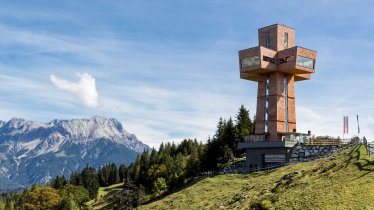
The KAT Walk Family in the Kitzbühel Alps is a long-distance hiking trail aimed specifically at families. Its five stages lead from the village of Hopfgarten via Brixen, Kirchberg, Kitzbühel and St. Johann to St. Ulrich am Pillersee. Hikers can look forward to fine views of mountains such as the Hohe Salve, the Hahnenkamm and the Kitzbüheler Horn. This adventure requires good overall fitness, though some stages can be shortened using cable cars. There is also the option of having your luggage transported for you from one accommodation to the next, leaving you free to enjoy the walk without a heavy bag on your back. Children can look forward to lots of great attractions along the way such as climbing areas, mountain-cart tracks, adventure play parks and an alpine flower garden on the Kitzbüheler Horn mountain.

Long-Distance Hiking Trail
Starting point
Top of Salvenbahn I cable car, Hopfgarten
Finishing point
St. Ulrich am Pillersee
Mountain chain
Kitzbühel Alps
Length
85.4 km
Duration
5 day(s)
Features
- Wheelchair-accessible Hiking Route
- Circular hike
Difficulty rating
intermediate (red mountain trails)
Altitude
Elevation uphill 4,900m
Vertical metres downhill 5,220m
Fitness level
Technique
Best time of year
* These are approximate values and recommendations. Please take your personal fitness level, technical ability and the current weather conditions into account. Tirol Werbung cannot guarantee that the information provided is correct and accepts no liability.
Public transport
- Accessible using public transport
Bf. Hopfgarten im Brixental Berglift (REX 3, S8)
Parking
Talstation der Salvenbahn
Einkehrmöglichkeiten:
- Etappe 1: Berggasthof Tenn, Alpengasthof Rigi,
Gipfelrestaurant Hohe Salve, Filzalm - Etappe 2: Brixenbachalm, Wiegalm, Kobingerhütte,
Bärstättalm, Gaisbergalm - Etappe 3: Bergschenke Krin, Maierl-Alm, Alpengasthof Ochsalm,
Gasthof Bergstation Hahnenkammbahn - Etappe 4: Adlerhütte, Gipfelhaus Kitzbüheler Horn, Harschbichlalm,
Stanglalm, Müllneralm, Bassgeiger-Alm, Alpengasthof Hirschberg, Berggasthof Hochfeldalm - Etappe 5: Alpengasthof Adlerspoint, Winterstelleralm
Downloads
Trail description
Stage 1: Hopfgarten – Brixen im Thale
Uphill/downhill: 650/1,017 vertical metres, walking time: 5 hours, distance: 10.2 kilometres, highest point: 1,829 metres, difficulty rating: intermediate
Take the Salvenbahn I cable car from Hopfgarten up to Innersalvenberg at almost 1,200 metres above sea level. It is here that the hike begins, first leading to the Kälberalm hut and then on to the top of the Hohe Salve mountain (1,829 metres). The route continues to the Filzalm hut and the settlement of Hochbrixen before concluding in Brixen im Thale.
Stage 2: Brixen im Thale – Kirchberg in Tirol
Uphill/downhill: 1,000/990 vertical metres, walking time: 6.5 hours, distance: 15 kilometres, highest point: 1,768 metres, difficulty rating: intermediate
Stage two leads along the banks of the Brixenbach river uphill in a southerly direction. After passing the Brixenbachalm hut and the Kobinger Hütte hut you will reach the Gaisberg mountain (1,770 metres). The stage ends in Kirchberg, with the route continuing on via the Bärstattalm hut and the Obergaisberg mountain.
Stage 3: Kirchberg in Tirol – Kitzbühel
Uphill/downhill: 980/1,021 vertical metres, walking time: 6.75 hours, distance: 16 kilometres, highest point: 1,802 metres, difficulty rating: intermediate
From Kirchberg, follow the KAT Walk signs via Krin to the Ochsalm hut and then on via the Kaseralm hut to an area known as the Ehrenbachhöhe (1,802 metres). From there, continue down to the Hahnenkamm (1,712 metres). After passing the top station of the Hahnenkammbahn cable car and the Seidlalm hut, descend to Kitzbühel. Some sections on this stage are rocky and exposed.
Stage 4: Kitzbühel – St. Johann in Tirol
Uphill/downhill: 1,280/1,366 vertical metres, walking time: 9 hours, distance: 22 kilometres, highest point: 1,996 metres, difficulty rating: intermediate
Stage four is relatively long and begins in the centre of Kitzbühel. Follow the "Hagsteinweg" (hiking trail number 31) via Reichern to the Adlerhütte hut. There, take hiking trail number 34 past the northern side of the Wilder Hag mountain up to the alpine flower garden and then on to the top of the Kitzbüheler Horn mountain (1,996 metres). Continue north via the Harschbichlalm hut, the Stanglalm hut and the Müllneralm hut down to St. Johann in Tirol. Some sections of this stage are rocky and exposed.
Stage 5: St. Johann in Tirol – St. Ulrich am Pillersee
Uphill/downhill: 990/830 vertical metres, walking time: 7.5 hours, distance: 21.4 kilometres, highest point: 1,546 metres, difficulty rating: intermediate
The final stage begins in St. Johann in Tirol and takes hikers past the horse-and-carriage racetrack in Oberhofen uphill to the Baumoosalm hut and then in an easterly direction to the Alpengasthof Adlerspoint. From there, continue to the Winterstelleralm hut and then head down to St. Ulrich am Pillersee, where the KAT Hike Family concludes.
For more information on the route and the luggage transport service available please click here.


