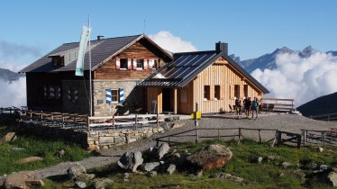
Rated easy to intermediate, this mountain hike begins in the village of Galtür and leads into high alpine terrain. As hikers pass through the Jamtal Valley they can enjoy wonderful views of the Silvretta Mountains as well as the Jamtalferner glacier and the Jamtalspitzen (3,156 and 3,178 metres) mountains plus the Dreiländerspitze (3,197 metres). Your final destination is the Jamtalhütte hut at 2,165 metres. Take time to catch your breath and enjoy the food at the hut before returning the way you came.

Mountain Hike
Starting point
Galtür, church
Hike to
Jamtalhütte
Finishing point
Galtür, church
Mountain chain
Silvretta Alps
Length
19.5 km
Total hiking time
6 h 30 min
Features
- Wheelchair-accessible Hiking Route
- Circular hike
Difficulty rating
intermediate (red mountain trails)
Altitude
Elevation uphill 651m
Vertical metres downhill 651m
Fitness level
Technique
Best time of year
* These are approximate values and recommendations. Please take your personal fitness level, technical ability and the current weather conditions into account. Tirol Werbung cannot guarantee that the information provided is correct and accepts no liability.
Public transport
- Accessible using public transport
Bus route 260, get off at stop Galtür Dorfplatz
Parking
Parking available on the edge of Galtür
Places serving food & drink
- Jamtalhütte (March, April, July until September)
- Large selection of locations in Galtür
Downloads
Trail description
From the bus stop at the church in Galtür (1,584 metres), head south into the Jamtal valley and along the Jambach stream on a moderate incline into the valley. Follow the footpath marked "Fußweg zur Jamtalhütte". The first stop is the Schnapfenalpe meadow (1,735 metres), which is reached after about an hour's walk. Cattle from Göfis in Vorarlberg and the Upper Inn Valley graze here. It is here that the terrain changes, with alpine pastures replaced by rocks. Cross two streams on wooden bridges before winding your way up to the Jamtalferner glacier and the Jamtalhütte (2,165 metres). Once at the hut, go round the back and check out the amazing views. The hut is an excellent place from which to climb the dozens of surrounding mountains.
Return along the same way you came.


