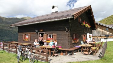
Located at 2,369 metres above sea level, between the Gschnitztal Valley and the Stubai Valley, the Innsbrucker Hütte is a popular destination and an important base for climbers wishing to explore the surrounding mountains. One of the most popular peaks to climb from the Innsbrucker Hütte is the Habicht (3,277 metres), though this is only recommended for experienced hikers. An easier option is the Kalkwand (2,564 metres) which offers fine views of the surrounding mountains. This version of the hike begins in the village of Gschniz and leads via the Innsbrucker Hütte to the Kalkwand.

Summit Hike
Starting point
Gschnitz
Hike to
Innsbrucker Hütte, Kalkwand
Finishing point
Gschnitz
Mountain chain
Stubai Alps
Length
14.2 km
Total hiking time
9h
Features
- Wheelchair-accessible Hiking Route
- Circular hike
Difficulty rating
intermediate (red mountain trails)
Altitude
Elevation uphill 1,338m
Vertical metres downhill 1,338m
Fitness level
Technique
Best time of year
* These are approximate values and recommendations. Please take your personal fitness level, technical ability and the current weather conditions into account. Tirol Werbung cannot guarantee that the information provided is correct and accepts no liability.
Public transport
- Accessible using public transport
Bus route 4146, get off at Gschnitz Gh. Feuerstein
Parking
In Gschnitz or at the car park at the end of the valley
Places serving food & drink
- Innsbrucker Hütte (June until October)
- Gasthof Feuerstein in Gschnitz
Downloads
Trail description
From the car park in Gschnitz, follow the road briefly into the valley to where a trail branches off to the right. This trail winds its way upwards across alpine meadows and pastures and partly through sparse forests and finally leads through steeper, unwooded terrain in a westerly direction to the Pinnisjoch ridge (2,369 metres). It is there that you will find the Innsbrucker Hütte at the foot of the Habicht and south-west of the white rockfaces of the Kalkspitze. Keep your eyes open for the signposts marked "Kalkspitze". From the Innsbrucker Hütte it takes around an hour to complete the final push up through scree to the rocky summit of the Kalkspitze (2,564 metres).
Return along the way you came.


