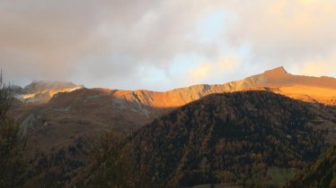
This five-day hike leads in an almost perfect heart shape through the Villgratental, Arntal and Winkeltal valleys in the Villgraten Mountains of East Tirol. Its name, "Herz-Ass Villgraten", means "Ace of Hearts Villgraten". The hike was first completed in 1988 by two locals, Norbert Mariacher and Konrad Hofmann. Broken up into five stages, it is still a serious challenge for ambitious hikers keen to explore the untouched beauty of East Tirol and admire plenty of fabulous views along the way. The hike, which begins in the village of Außervillgraten, is made up of almost 80 kilometres and 5,700 vertical metres of climbing.

Starting point
Innervillgraten
Finishing point
Thurntaler Rast (Thurntaler mountain)
Mountain chain
Villgraten Mountains
Length
77.7 km
Duration
5 day(s)
Features
- Wheelchair-accessible Hiking Route
- Circular hike
Difficulty rating
difficult (black trails)
Altitude
Elevation uphill 5,733m
Vertical metres downhill 4,899m
Fitness level
Technique
Best time of year
* These are approximate values and recommendations. Please take your personal fitness level, technical ability and the current weather conditions into account. Tirol Werbung cannot guarantee that the information provided is correct and accepts no liability.
Public transport
- Accessible using public transport
Parking
Parking next to the municipal centre ("Gemeindeamt") in Außervillgraten
Places serving food & drink
- Stage 1: Reiterstube (closed on Tuesdays)
- Stage 2: Volkzeiner Hütte (early June until the second half of October)
- Stage 3: Unterstalleralm (mid-May until mid-October)
Downloads
Trail description
Stage 1: Außervillgraten – Reiterstube
Uphill/downhill: 1,182/935 vertical metres, walking time: 8 hours, distance: 18.1 kilometres, highest point: 2,350 metres, difficulty: intermediate (red)
The first stage begins in Außervillgraten and leads across the northern flank of the Glinzzipf mountain, initially through pine and larch forests and later through open pastureland, in a north-easterly direction into the Winkeltal Valley. At the Tilliachalm hut (closed) hikers can take a slight detour to the "Herrgottslärche", a fine depiction of Jesus Christ carved into a tree. The final section leads down along the Tilliachbach river to the Reiterstube in the valley.
Stage 2: Reiterstube – Villgrater Joch – Volkzeiner Hütte
Uphill/downhill: 1,217/805 vertical metres, walking time: 7 hours 15 minutes, distance: 13.2 kilometres, highest point: 2,583 metres, difficulty: intermediate (red)
In the Winkeltal Valley, initially follow the "Salzsteig" trail. When you reach the Brunneralm hut, take trail number 323 in an easterly direction and ascend towards the Villgrater Joch ridge (2,583 metres). After a slight detour to the ridge itself, head back to the main trail and continue in a north-westerly direction via the Leisacher Alm hut to the Volkzeiner Hütte (1,886 metres).
Stage 3: Volkzeiner Hütte – Arntaler Lenke – Unterstalleralm
Uphill/downhill: 794/979 vertical metres, walking time: 6 hours, distance: 11.2 kilometres, highest point: 2,655 metres, difficulty: intermediate (red)
At the Volkzeiner Hütte, cross the stream and head through the pastureland of the Schrentebachboden to the Arntaler Lenke (2,655 metres). If you have enough energy, we recommend a slight detour to the Goldtrögele and the Degensee lake (2,720 metres). The route continues over the Arntaler Lenke with majestic views of mountains including the Großglockner, Austria's highest peak, before descending into the Stallertal Valley, past the protected buildings of the Oberstalleralm hut down to the Unterstalleralm. It is here that you can look forward to a hearty meal and a warm bed for the night.
Stage 4: Unterstalleralm – Heimwaldjöchl – Kalkstein
Uphill/downhill: 1,221/1,271 vertical metres, walking time: 8 hours, distance: 12.4 kilometres, highest point: 2,583 metres, difficulty: intermediate (red)
From the Unterstalleralm hut, the route continues in a westerly direction. The first section leading through lush pastures eventually gives way to more rocky terrain with the impressive Schwarzsee lake at almost 2,500 metres above sea level. From the lake, continue in a southerly direction beneath the Riepenspitze mountain (2,774 metres) – which can be climbed if you have the time and energy – over the Heimwaldjöchle ridge (2,644 metres), the summit of the Gail mountain (2,494 metres) and down to Kalkstein.
Stage 5: Kalkstein – Toblacher Pfannhorn – Thurntaler Bergstation (Gondel)
Uphill/downhill: 1,374/917 metres, walking time: 9 hours 10 minutes, distance: 22.7 kilometres, highest point: 2,663 metres, difficulty: intermediate (red)
The fifth and final stage leads from Kalkstein through the Alfental Valley along a section of the Bonn High Trail with its many wartime bunkers to the highest point of the stage and possibly of the entire Herz Ass Villgraten hike: the Toblacher Pfannhorn (2,663 metres). From here, hikers can enjoy fine views of the Dolomites and the famous Drei Zinnen. The route then continues in an easterly direction via the Blankenstein mountain, the Marchkinkele and the Thurntaler See lake to the top of the Thurntaler-Gondelbahn cable car, which takes you down to Sillian.


