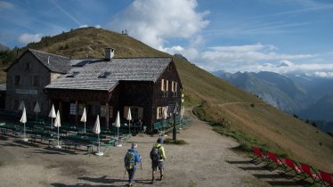
Eagle Walk Stage O5: Badener Hütte, © Badener Hütte

Eagle Walk Stage O5: Badener Hütte - Matreier Tauernhaus

Sprawling sparkling glaciers spreading out in all directions await the eager Eagle Walk hiker. Most of the way is along the Venediger High Trail, allowing you to sample one of the most famous long-distance hiking trails in the region. Heading north, a gentle gradient takes you up to Löbbentörl, from where you’ll have wonderful views of the surrounding Venediger Range and the Froßnitztal Valley below. Passing Salzboden and the tiny lake of the same name, the Glacier Trail aims eastward to Venedigerhaus hut at Innergschlöss serving hearty delicacies to hungry trekkers. Once replete and replenished the trail continues to Außergschlöss and to the destination of the hike, the Matreier Tauernhaus hut. What a workout!

Interesting Facts

Eagle View ·The loop walk along fascinating Innergschlöss Glacier Trail takes some four hours to complete and gains 500 vertical metres. Walkers should be sure-footed. Once at the Matreier Tauernhaus, you can either rest or continue on to a pair of very pretty small lakes deeper in the surrounding wilderness. The rock chapel located between the alpine pastures of Innergschlöss and Außergschlöss is a historic structure in Neo-Gothic style that is located directly on the Eagle Walk. Simply contemplate your good fortune while sitting here, surrounded by pure mountain beauty.

Eagle Kick ·What a workout! The walk from Badener Hütte across Löbbentörl to the Venedigerhaus hut alone takes 4 to 4.5 hours to complete, with a knee-jarring descent from Löbbentörl to Innergschlöss. It’s a long journey, and steep in places, but manageable nonetheless. Hikers are rewarded with outstanding views, clean air and stunning natural beauty.

Interesting Facts Eagle View ·The loop walk along fascinating Innergschlöss Glacier Trail takes some four hours to complete and gains…

Read moreShow less
Open interactive map

Starting point  

Badener Hütte

Finishing point

Matreier Tauernhaus

Mountain chain

Venediger Mountains

Length

14 km

Total hiking time

5 h 30 min

Features

  • Wheelchair-accessible Hiking Route
  • Circular hike

Difficulty rating

intermediate (red mountain trails)

Altitude

2,760m 1,500m

Elevation uphill 450m
Vertical metres downhill 1,550m

Fitness level

Technique

Best time of year

Jan
Feb
Mar
Apr
May
Jun

Jul
Aug
Sep
Oct
Nov
Dec

* These are approximate values and recommendations. Please take your personal fitness level, technical ability and the current weather conditions into account. Tirol Werbung cannot guarantee that the information provided is correct and accepts no liability.

Eagle Walk

This is a stage of the Eagle Walk, Tirol's most famous long-distance hiking trail.

Downloads

Trail description

Starting Point: Badener Hütte

From the Badener Hütte (2,608 m) follow the Venediger High Trail that coincides with the Eagle Walk (also called the "Badener Trail" on this section) northwards up to the Löbbentörl ridge (2,770 m). On your way you will cross rocky chutes and tiny gorges, with some sections assisted by a fixed anchoring system of cables. Proceed up over rocks and boulders for the ascent of the Löbbentörl ridge, first gradually then more steeply. Atop you will find a huge crucifix playing host to one of the most iconic views in the Venediger Range. From there, the trail drops steeply, descending a rocky flank and a grassy ridge that are prone to retaining snow well into summer. Descend a series of zigzags over rocks and boulders to gain the lateral moraines of Schlatenkees glacier. Fixed wires are in place to aid stability. Follow the rocky trail down to the foot of Keesboden glacier. Here there is a trail which branches off to the Alte Prager Hütte (not open to the public), while another one heads along fascinating Innergschlöss Glacier Trail. The Venediger High Trail proceeds past Salzbodensee lake (2,731 m), a tiny lake that reflects the faces of the Hoher Zaun and Schwarze Wand mountains when the winds are calm and the air is clear. North of the glacier-fed Gschlössbach stream, the trail makes a sharp bend eastward and takes you to the Venedigerhaus hut providing the perfect rest stop for hikers at an elevation of 1,689 metres.

Food & drink: Venedigerhaus

The route then heads out of the valley along the banks of Gschlössbach stream. The historic rock chapel located between the alpine pastures of Innergschlöss and Außergschlöss is a perfect place for calling it a day and savouring views surrounded by pure mountain beauty. The Berghaus Außergschlöss (1,700 m) is another strongly recommended rest stop for hikers. Once the valley widens, it’s a gentle downhill stroll from Gschlöss to the Matreier Tauernhaus, dropping some 200 metres within an hour. Perched at an elevation of 1,512 metres, the hut is just the right place to recover from the knee-jarring descents of this walk over hearty local delicacies. Descriptions of the trails can also be found in the book "Osttiroler Wanderbuch" by Walter Mair.

Finishing point: Matreier Tauernhaus

Information on place

Arrival date

How to get here by plane, train, bus or car.

Ihr Ziel: Eagle Walk Stage O5: Badener Hütte - Matreier Tauernhaus (47.081220061571,12.425527399027)

powered by Rome2Rio

Search accommodation

Number of travelers

Hiking trails in this region

show more +

How did you like this article?

Want to receive an answer? If so, please get in touch using the contact form.

Go up

Is your inbox in need of a holiday?

Then subscribe to our weekly newsletter full of exclusive holiday tips from Tirol!