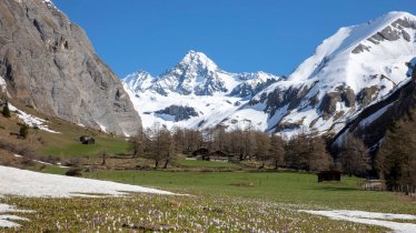
View from Kreuzspitze mountain to the Großvenediger, © Friedl Kratzer

Eagle Walk Stage O2: Johannis Hütte - Eissee Hütte

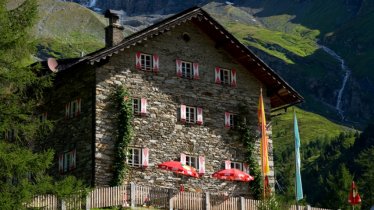
The journey continues through the fascinating landscape of the high Alps from the Johannis Hütte towards the Kreuzspitz-Höhenweg high-altitude trail, passing lush green meadows and later rocky terrain. Hikers have the option of a "detour" to the top of the Kreuzspitze peak with its majestic views of the Großvenediger. Fine hiking and breathtaking views are the reward for a long ascent. The Eagle Walk itself leads to the Neue Sajathütte, known as the "castle in the mountains", but it is still quite a way from there to the official end point of this stage: the Eissee Hütte.

Interesting Facts

Eagle View · There are few more spectacular experiences than hiking in the high Alps with their majestic glaciers. Take a "detour" via the Kreuzspitze peak for some incredible views of the mighty Großvenediger mountain.

Eagle Kick ·The section between the Johannis Hütte and the Sajathütte is known as the "Schernesschaft" and comprises an exposed ridge requiring hikers to be 100% sure-footed and not afraid of heights. The crossing of the nearby Schernersschlucht canyon is also a memorable experience.

Interesting Facts Eagle View · There are few more spectacular experiences than hiking in the high Alps with their majestic glaciers. Take a…

Read moreShow less
Open interactive map

Starting point  

Johannis Hütte

Finishing point

Eissee Hütte

Mountain chain

Venediger Mountains

Length

11 km

Total hiking time

5h

Features

  • Wheelchair-accessible Hiking Route
  • Circular hike

Difficulty rating

difficult (black trails)

Altitude

2,750m 2,110m

Elevation uphill 1,250m
Vertical metres downhill 840m

Fitness level

Technique

Best time of year

Jan
Feb
Mar
Apr
May
Jun

Jul
Aug
Sep
Oct
Nov
Dec

* These are approximate values and recommendations. Please take your personal fitness level, technical ability and the current weather conditions into account. Tirol Werbung cannot guarantee that the information provided is correct and accepts no liability.

Eagle Walk

This is a stage of the Eagle Walk, Tirol's most famous long-distance hiking trail.

Downloads

Trail description

Starting point: Johannis Hütte

Leaving the Johannis Hütte, the Eagle Walk continues along the Venediger Höhenweg trail in an easterly direction. After around an hour hikers will reach a small high valley, where they should follow the signs for "Kreuzspitz-Höhenweg". This heads first in an southerly direction towards the Scherneskopf before turning off north. It is here that a series of switchbacks begin, taking hikers up to the exposed Schernesschaft ridge at 3,040 metres above sea level. Continue along this ridge – which has a steel rope anchored into the rock for safety – towards the Sajathütte hut. Those who have enough energy can climb the Kreuzspitze peak (3,155 m) with its fine views of the Großvenediger. However, hikers should be aware that there is still a relatively long section to complete from the Sajathütte hut to the day's final destination.

Food & drink: Neue Sajathütte

First walk down a steep chute with loose rocks. Then proceeding on sandy terrain at the foot of the Rote Säule mountain. Finally, wander across a grassy slope to reach the Sajathütte hut (2,575 m). This is the perfect rest stop for hikers. Once replete and replenished, follow the Prägraten High Trail towards the Eissee Hütte hut. This route links the Sajathütte to the Eissee Hütte without having to descend to the valley floor. Leaving the Sajathütte, aim eastwards and round the southeast ridge of the Vorderer Sajatkopf peak at the so-called "Fenster" ("window"). From there, the trail heads northward and traverses a few chutes and gullies; they are quite easy to negotiate as there is a fixed anchoring system of cables. Ascend via a steep path that is moderated with switchbacks at times. Continue across the Inner Timmeltal Valley until you reach “Hinteres Wiesach”, where the steep gradient lessens. Cross the Timmelbach stream and wander across meadows to reach the quaint and lovely Eissee Hütte (2,521 m).

Finishing point: Eissee Hütte

IMPORTANT: As an alternative to this very difficult stage, hikers can instead walk from the Johannis Hütte straight over the Zopetscharte ridge to the Eissee Hütte. Walking time: approx. 4 hours, red (intermediate) trail; not an official walking path – hikers must be sure-footed

Information on place

Arrival date

How to get here by plane, train, bus or car.

Ihr Ziel: Eagle Walk Stage O2: Johannis Hütte - Eissee Hütte (47.059844883735,12.334495691599)

powered by Rome2Rio

Search accommodation

Number of travelers

Hiking trails in this region

show more +

How did you like this article?

Want to receive an answer? If so, please get in touch using the contact form.

Go up

Is your inbox in need of a holiday?

Then subscribe to our weekly newsletter full of exclusive holiday tips from Tirol!