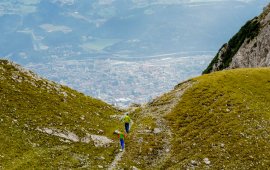
Eagle Walk Stage 12, © Tirol Werbung/Gigler Dominik

Eagle Walk Stage 12: Hallerangerhaus - Pfeishütte - Hafelekar - Nordkette Innsbruck

This stage of the Eagle Walk is where you get the best of both worlds – the urban sophistication of an historic city and remote mountain wilderness. Follow the track towards the Lafatscherjoch ridge, continue onto the Wilde-Bande-Steig trail towards the Stempeljoch ridge and then make a steep ascent to Stempeljoch saddle before you gently descend to the Pfeishütte hut. On a gentle upward path, proceed towards the Arzler Scharte col, where the Goetheweg trail starts. From there on out, a steep climb leads up to Mandlscharte and then on to the Mühlkar. Make your way uphill between Gleirschspitze summit and Mandlspitze summit, where the view extends over the Inn Valley and the surrounding mountain ranges such as the Tux Alps and the Stubai Alps. Continue hiking on the Goetheweg trail towering high above the glistening Inn river in the valley below. From Hafelekar, you can take the Nordkette Gondola down to Innsbruck, the lively capital city of Tirol. Architectural gems lurk around every corner in the oldtown. Stroll around the quaint streets of this magical town, where you will find a host of exciting sights and attractions.


Interesting Facts

Eagle View ·The Hafelekar measuring station is an observatory for cosmic radiation of the University of Innsbruck. It was initiated by Victor Franz Hess (1883-1964), a Nobel Prize winner in physics. Cast a glance through a window opening and see the beginnings of high-energy physics. However, the magnificent views into the Inntal Valley from Goetheweg trail also have a highly energetic effect. The mountain town is a most welcoming place!

Eagle Kick ·Noted for being among Europe’s longest and most difficult downhills, Nordkette Singletrack Trail provides a stack of options for downhill riders. Trailhead of Nordkette Singletrack Trail is Seegrube at an elevation of 1,905 metres. Daredevil, seriously expert level riders master the Nordkette Singletrack Trail downhill in 10 minutes. Not for the faint-hearted this one!

Open interactive map

Starting point  

Hallerangerhaus

Finishing point

Innsbruck

Mountain chain

Karwendel Mountains

Length

13 km

Total hiking time

5 h 30 min

Features

  • Wheelchair-accessible Hiking Route
  • Circular hike

Difficulty rating

difficult (black trails)

Altitude

2,280m 570m

Elevation uphill 1,150m
Vertical metres downhill 970m

Fitness level

Technique

Best time of year

Jan
Feb
Mar
Apr
May
Jun

Jul
Aug
Sep
Oct
Nov
Dec

* These are approximate values and recommendations. Please take your personal fitness level, technical ability and the current weather conditions into account. Tirol Werbung cannot guarantee that the information provided is correct and accepts no liability.

Eagle Walk

This is a stage of the Eagle Walk, Tirol's most famous long-distance hiking trail.

Downloads

Trail description

Starting point: Hallerangerhaus

From the Hallerangerhaus follow the footpath towards “Lafatscher Joch”. The path takes you through a scree and talus field that gets steeper and narrower as you walk along. The trail will then lead to the so-called “Durchschlag” (here the old mule track was carved into the rock) and you will pass a cross before reaching a plateau, where you will find a turnoff towards the Speckkarspitze mountain. Walk across the plateau to the north and you will soon reach the Lafatscherjoch ridge. Here, follow signage to “Pfeishütte”. This trail is a gentle downhill stroll. Follow signage to “Pfeishütte” and/or “Pfeishütte über Wilde-Bande-Steig”. The pristine Wilde-Bande-Steig trail is a gentle ascent taking you along dwarf pines and across gullies until you reach the entrance to the cirque below Stempeljoch ridge. Follow signage to “Stempeljoch” and/or “Pfeishütte”. You have to master steps made of planks and ropes. The trail is getting steeper, while the unstable scree ground will be easier further uphill. Turn right at the ridge and stroll down along meadows and alpine pastures towards the Pfeishütte hut.

Food & drink: Pfeishütte

The way-marked Goetheweg trail (trail number 219) has its trailhead at the hut. The trail is a gentle ascent to the basin south of the shelter. Follow the next turnoff towards “Mandlscharte” and/or “Hafelekar Bergstation”, then take the right fork (to the left the trail branches off towards Arzler Scharte) and a wide loop will take you uphill crossing a scree and talus slope to the Mandlscharte. The descent on the backside leads through talus before merging into a well-maintained and quite wide path that evenly crosses the talus beneath rock faces. This section offers a scenic view of the backside of the lofty Nordkette Mountains. After a short climb, the trail changes to the side of the Inn Valley, where a few switchbacks will take you downhill. This is followed by a gentle ascent along an excellent path on the grassy southern flank of the Nordkette towards the west until you reach the top gondola station at Hafelekar. Always follow signage to “Hafelekar Bergstation” and/or “Goetheweg”. This final section of the trail meanders from the north to the south side of the ridge time and again.

Food & drink: Hafelekarhaus

Travel down on the gondola to Seegrube.

Food & drink: Alpenlounge Seegrube

Ride the gondola and space-age funicular down to the heart of Tirol’s lively capital Innsbruck. Alternativly, you can walk down on foot.

Finishing point: Innsbruck

Tip! If you don't manage to see a golden eagle in the wild then there is always the Alpenzoo overlooking Innsbruck, where visitors will find the golden eagles Max and Donna. The zoo is easy to reach. Simply travel down towards the city on the Nordkette Funicular and get off at the stop named "Alpenzoo". From there it is just a short walk from to the zoo entrance.

Information on place

Arrival date

How to get here by plane, train, bus or car.

Ihr Ziel: Eagle Walk Stage 12: Hallerangerhaus - Pfeishütte - Hafelekar - Nordkette Innsbruck (47.3546773,11.4771348)

powered by Rome2Rio

Search accommodation

Number of travelers

Hiking trails in this region

show more +

How did you like this article?

Want to receive an answer? If so, please get in touch using the contact form.

Go up

Is your inbox in need of a holiday?

Then subscribe to our weekly newsletter full of exclusive holiday tips from Tirol!