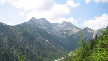
This circular hike offers fine views of the Rofan Mountains, the Karwendel Mountains and the Kaiser Mountains as well as the shimmering turquoise waters of Lake Achensee. It is 17 kilometres in length and leads from Steinberg am Rofan to the abandoned Kotalm hut and the Vorderunnutz mountain (2,078 metres) before returning via the Kögljoch ridge to the starting point. Hikers need good overall fitness to complete this walk, which is rated of intermediate difficulty and has around 1,000 vertical metres of uphill. Make sure you plan a little time for a stop at the Schönjochalm hut serving delicious local food.
Starting point
Steinberg am Rofan
Hike to
Vorderunnutz (2,078 metres)
Finishing point
Steinberg am Rofan
Length
17.1 km
Total hiking time
7h
Features
- Wheelchair-accessible Hiking Route
- Circular hike
Difficulty rating
intermediate (red mountain trails)
Altitude
Elevation uphill 1,010m
Vertical metres downhill 1,010m
Fitness level
Technique
Best time of year
* These are approximate values and recommendations. Please take your personal fitness level, technical ability and the current weather conditions into account. Tirol Werbung cannot guarantee that the information provided is correct and accepts no liability.
Public transport
- Accessible using public transport
Bus 7801 from Achenkirch, get off at stop Steinberg a. R. Obersteinberg
Parking
Liftstüberl car park
Downloads
Trail description
This circular hike begins at the Liftstüberl car park in Hintersteinberg. First follow the trail to the south, then after 50 metres turn right and head towards the Gfaßsattel and Schönjochalm. The wide alpine path leads west through shady mountain forestland, veering north after a few kilometres towards the abandoned Kotalm (1,449 metres). It is here that the ascent to Vorderunnutz begins. The trail slowly becomes steeper and rockier. On a long flank at an altitude of about 1,900 metres the path becomes less steep again and you can enjoy the view of the Guffert and surrounding mountains. Shortly before reaching the summit you will get your first glimpse of the shimmering turquoise Lake Achensee far below.
The descent leads along a steep trail through mountain pines southwards to the Kögljoch ridge. Once there, turn left and follow the farm track down to the Schönjochalm (1,287 metres), where you can treat yourself to a well-deserved break. Then hike along the alpine path downhill back to Steinberg.


