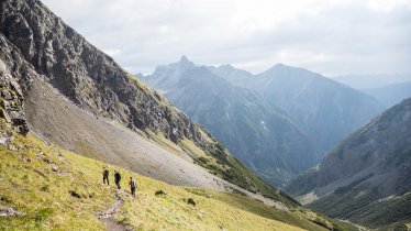
This circular walk of intermediate difficulty in the Arlberg Mountains leads from St. Christoph over the regional border to the Kaltenberghütte hut in neighbouring Vorarlberg. Walkers can look forward to untouched nature and total peace and quiet. From the Maroital Valley there are fine views of St. Anton and the impressive Patteriol peak (3,056 metres) to the south. The Kaltenberghütte hut itself also has a majestic panorama of the Klostertal Valley all the way to the Flexenpass (1,773 metres) and the Lech Alps and Verwall Massif on the other side of the valley. The lake next to the hut, at almost 2,000 metres above sea level, provides refreshment on hot days.

Mountain Hike
Starting point
St. Christoph am Arlberg
Finishing point
St. Christoph am Arlberg
Mountain chain
Verwall Mountains
Length
15.3 km
Total hiking time
6 h 30 min
Features
- Wheelchair-accessible Hiking Route
- Circular hike
Difficulty rating
intermediate (red mountain trails)
Altitude
Elevation uphill 780m
Vertical metres downhill 780m
Fitness level
Technique
Best time of year
* These are approximate values and recommendations. Please take your personal fitness level, technical ability and the current weather conditions into account. Tirol Werbung cannot guarantee that the information provided is correct and accepts no liability.
Public transport
- Accessible using public transport
Parking
Car park on top of Findelkindtunnel (plus other options)
Places serving food & drink
- Albona Bergrestaurant
- Kaltenberghütte (late June until early October)
- Various locations in St. Christoph
Downloads
Trail description
Above the Gasthof Valluga in St. Christoph is where we start our hike. A trail leads gently uphill through the Maroital Valley to the top of the cable car station at Albonagrat and then, mostly gently downhill, over to the Kaltenberghütte hut. From there, take the "Paul-Bantlin-Weg" trail downhill past the Albonaseen lakes back to St. Christoph.


