Description
Difficulty: intermediate
Fitness required: intermediate
Ideal for: experienced hikers
Route: Hochpillberg, Weg der Sinne - Naunz Niederleger - Wopfneralm - Loasweg
Route description: Same start as the
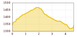
Family Hiking Trail (see below). From Hoferweg, at the waysign of the "Weg der Sinne" (Path of the Senses) go uphill, on a narrow path you pass several works of art until the forest this out and you reach a clear area at the Naunz. Proceed uphill directly over the clear area in direction Naunz Niederleger. Halfway up, turn right and walk towards the free-standing cabin. Here you reach the highest point of this routhe and the breathtaking panorama of the Pillberg and Karwendel lies before you. Down you follow a forest road that keeps getting steeper, it first goes South and then back down to the Wopfneralm.
Abstieg: The route leads from the Wopfneralm over the (unofficial) tobbogan run Loasweg back to the parking lot.
Please pay attention to the current avalanche warning level (https://lawinen.report/bulletin/latest) and always act on your own responsibility.
Anfahrt:Autobahn exit A12 Schwaz, from there to Pill → Pillberg, at Hochpillberg to parking lot Hochpillberg (see below).