Winter hike Mösernrunde

closed
Obertilliach / Gailtaler Alpen
Difficulty ratings: easy
Route length: 4.2 km
Duration: 1:30 h

Sunny winter hiking trail from Obertilliach through the Tilliacher Feldflur to the "Möser" and back.
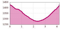
Tour information

  • Requirement: easy
  • Length: 4.2 km
  • Duration: 1:30 h
  • Elevation uphill:151 hm
  • Elevation downhill:149 hm
Highest point1,446 m

Starting point

Bushaltestelle Obertilliach/Ort - Zollstöckl
  • Fitness level 2 / 6
  • Technique 2 / 6

Features

  • Circular route

Best time of year

  • January
  • February
  • March
  • April
  • May
  • June
  • July
  • August
  • September
  • October
  • November
  • December

Trail condition

Geräumter bwz. gewalzter Winterwanderweg

Equipment

Festes Schuhwerk und Winterbekleidung

Description

Starting on the southern side of the village centre, the Mösernrunde takes a pleasant route through the Möser along the Bachhäuselbach stream towards Bergen. After crossing the Bachhäuselbach stream, you return to the centre of Obertilliach.

More tours in the surrounding area

Newsletter

The mountain is calling? So does our newsletter!

In our monthly newsletter we reveal the best holiday tips for Tyrol.