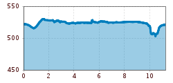
Long valley walk

Start from Strass community hall (Gemeindehaus), head west to the pedestrian crossing, then walk along Rotholzerstrasse towards Rotholz, past Gasthof Knapp and the last few houses as you head west. On the left, a path runs beside the road and then leads into the woods. Carry on until Knappenhof in Rotholz, towards the Lindenallee, then back zo the east an near the junction go left to the Inndamm (cycleway and footpath). Continue in an easterly direction, past the pumping station and the water treatment works, continue alongside the Ziller towards Schlitters to the Schlitterer See (lake), go to the right past the lake along the fields via Seehüter and Watsch back to Strass.