Winter hike Hollbruckertalweg

closed
Difficulty ratings: medium
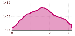
Route length: 3.1 km
Duration: 1:30 h

Moderate winter hike into the Hollbruckertal valley
Tour information

  • Requirement: medium
  • Length: 3.1 km
  • Duration: 1:30 h
  • Elevation uphill:80 hm
  • Elevation downhill:80 hm
Highest point1,439 m

Starting point

car park Hollbruck

Finishing point

car park Hollbruck
  • Fitness level 3 / 6
  • Technique 3 / 6

Features

  • Circular route

Best time of year

  • January
  • February
  • March
  • April
  • May
  • June
  • July
  • August
  • September
  • October
  • November
  • December

Description

The starting point is the car parkin Holbruck near the Maria Hilf pilgrimage church. The path leads past the Schneiderhöfe and into the Hollbrucktal valley and back again. It affords a wonderful panoramic view of the Carnic main Alpine ridge. Connection possibility: Hollbrucker circuit and Schustertalweg via a connecting section.

Getting here

  • Parking

    Parkplatz neben der Kirche in Hollbruck

More tours in the surrounding area

Newsletter

The mountain is calling? So does our newsletter!

In our monthly newsletter we reveal the best holiday tips for Tyrol.