Winter hike Gerloser Wiesenweg

Gerlos, Zillertal / Kitzbüheler Alpen
Difficulty ratings: medium
Route length: 7.9 km
Duration: 2:30 h

Gerloser Wiesenweg

Tour information

  • Requirement: medium
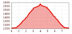
  • Length: 7.9 km
  • Duration: 2:30 h
  • Elevation uphill:300 hm
  • Elevation downhill:300 hm
Highest point1,600 m

Starting point

Isskogelbahn valley station (1.300m)

Finishing point

Isskogelbahn valley station (1.300m)
  • Fitness level 2 / 6
  • Technique 2 / 6

Description

The hike over the "Gerloser Wiesenweg" begins in the Innertal at the parking of the Isskogelbahn. Before the Krummbach Bridge the road leads left past the "Landhaus Platzer". After approx. 100 m, the path road branches off to the right. Always following the "Gerloser Wiesenweg" uphill, you reach the "Rössl Alm" in about 1 hour.
Return on the same route.

Getting here

  • Arrival by public transport

    With the bus 4094 to Gerlos.
    Exit point: Isskogelbahn

  • Parking

    At the Isskogelbahn

Newsletter

The mountain is calling? So does our newsletter!

In our monthly newsletter we reveal the best holiday tips for Tyrol.