Trail running Trailrun - "Via Claudia Augusta" section Prutz - Fließ

Prutz-Faggen /
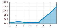
Route length: 6.9 km

Easy trailrun for beginners.
Tour information

  • Length: 6.9 km
  • Elevation uphill:324 hm
  • Elevation downhill:114 hm
Highest point1,071 m

Starting point

Prutz

Finishing point

Fließ

Description

From Prutz this hike leads over the bridge to the Entbruck district. The path leads right to the Pontlatzbrücke bridge, from there immediately left along the Inntalradweg to the power station, then take the stairs on the right and cross the main road. It follows a cart path to Fließ on the right (signposted).

Newsletter

The mountain is calling? So does our newsletter!

In our monthly newsletter we reveal the best holiday tips for Tyrol.