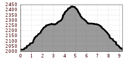
The Schwarzmoosrunde trail

The Schwarzmoosrunde trail first leads east across the car park by the Hochalterbahn chairlift and then zigzags up a forest path. Once you have left the Nederbach stream and the Kaiser-Max-Hütte mountain hut behind you, the route turns right to follow the mountain path under the Schwarzmooslift drag lift. From there, it's only a few vertical metres up to the highest point of the trail, the mountain lift station of the Kaiserbahn chairlift that sits at an altitude of 2,443 m above sea level. From there, you head back down to the tourist information centre with wonderful views of the Schwarzmoos lakes and the Sellrain Valley.