Arrival by public transport
Direct bus connection with the Regiobus line 590 to Neustift, bus stop "Neustift Dorf"
The Stubai High Trail on the run, only the " toughest" start here

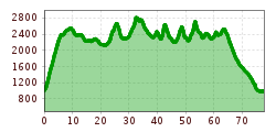
Where every mountain hiker spends at least a week on the trail, the best trail runners will choose their winner. From Neustift via 8 mountain huts once around the Stubai Valley, you will never forget these 80 km with almost 6000 meters of altitude. Incredibly far, incredibly hard, incredibly beautiful, if you can complete the adventure with the finish in Neustift.
Direct bus connection with the Regiobus line 590 to Neustift, bus stop "Neustift Dorf"
Parking spaces in Neustift after the roundabout at the leisure centre or in the "Bachertal" car park (subject to charge)