Arrival by public transport
Direct bus connection from the Stubaital to Innsbruck main station. (Line: ST590)
Really an ultra trail, long, difficult with great views and impressions

The STUBAI ULTRATRAIL K67 is the ultimate challenge in the heart of the Alps.
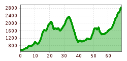
Under the motto "CITY2GLACIER" it's up to you to run within one day from the Olympic city of Innsbruck in the middle of Tyrol up to 22,960 metres above sea level on the Stubai Glacier - from the city to the eternal ice. The STUBAI ULTRATRAIL - CITY2GLACIER stands for an incomparable adventure. On a total distance of over 67 kilometres, the run combines urban feeling with top physical performance in an impressive natural landscape.5,110 metres in ascent and 2,820 metres in descent have to be mastered. The race starts at the Landestheater Vorplatz in Innsbruck and continues on varied trails to the end of the Glacier Valley, where the spectacular final ascent over snow and ice to the mountain station Eisgrat (2,960 m) at the Stubai Glacier awaits the runners.
Direct bus connection from the Stubaital to Innsbruck main station. (Line: ST590)
In the Congress Innsbruck parking garage.