Arrival by public transport
KaiserJet/Postbus stop “Söll Dorf”.
More information at: www.wilderkaiser.info/mobil
The Schattseit trail, mystical and refreshing in equal measure, is a section of the infamous Kaisermarathon, probably the toughest mountain marathon in the Alps.

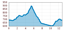
This route starts in the village center of Söll. First you run about 1.5 km through the village of Söll along the asphalt sidewalks. From the village of Bach, starts the narrow hiking trail, which was built in 2007 and is laid out almost mystically at the edge of the forest. For the runners, the view is always in the direction of the Wilder Kaiser and along the way, with the toilet Söller Freiheit and the Lebensbründl fountain, there are both stations to relieve yourself and to refresh.
After the Gasthof Bocking inn there is again a fast asphalted flat part of about 1.5 km, until you come to the energy trail section after the Mühlboden bridge.
The last climb awaits you after the Gasthof Oberstegen inn up to the Moorsee lake and the Franzlhof. From here it's a slight downhill return to the village center of Söll.
KaiserJet/Postbus stop “Söll Dorf”.
More information at: www.wilderkaiser.info/mobil
West Pölven public car park, Söll (689 m) – free