Arrival by public transport
By train to Kufstein or Wörgl station from there continue with the Regiobus 4026 to the bus stop Bad Häring Dorf.
The loop over the Pölven peaks is beautiful, but should not be underestimated. The trails are steep and partly exposed. Surefootedness and a head for heights are the prerequisites for spending a good time here. The view into the Inn Valley and also the Kaiser is breathtaking and those who like it a little more technical will have a lot of fun here. For beginners only conditionally suitable.

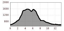
Starting in Bad Häring, you first follow the asphalt road steadily uphill into the Lengau. Short sections can be shortened here via hiking trails. When you reach the Lengau (beginning of the alpine meadow), the path leads steeply away to the left. From here you cover the next 600 meters in altitude within about 1.2 kilometers on a forest trail. A short passage has to be overcome via an airy ladder, followed by two short, very easy climbing passages, where hands can be helpful. At the top you will find the Häringer Kreuz or also called Pölvenkreuz on the left hand side with a great view over the Inn valley towards Innsbruck and the Kitzbühel Alps.
From there, the trail follows a slight up and down along the ridge and meanders through the mossy, mystical-looking landscape. Passing the Mittagskogel (Großer Pölven), you lose some altitude meters, walk straight ahead at the turnoff to Söll and now reach the Schwoicher Kreuz, the small Pölven. Steeply downhill you follow the trail with great caution. The path is partly very slippery and exposed, although you are in the forest. Until you reach Peppenau, you have left most of the altitude behind you. Following the signs to Bad Häring, from here you return to the starting point via a mix of forest, hiking and asphalt roads.
Caution: In wet conditions, the descent to Schwoich is tricky!
By train to Kufstein or Wörgl station from there continue with the Regiobus 4026 to the bus stop Bad Häring Dorf.
Hiking parking lot at the elementary school/ church