Arrival by public transport
bus stop Gondelbahn Hochbrixen
railway station Brixen im Thale
Glowing thighs and marvellous views!

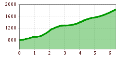
We start our summit assault on the Hohe Salve at the Hochbrixen gondola valley station in Brixen. Directly behind the cable car station, a road leads us uphill to the Ochsenweide junction. We keep left and stay on the tarmac road for a few hairpin bends. When we reach the houses, we turn left onto the mountain hiking trail, and from now on we head vertically uphill. Accordingly, we quickly leave the first metres of altitude behind us.
Once we reach the Hochbrixen high plateau, the route is flat back to the Filzalmsee lake before the next vertical ascent awaits us. We continue uphill across the alpine pastures, past the Jordan Chapel, from which a healing spring flows. Then it's on to the Kälbersalvenalm, past the Salvensee lake, and we're already on the final ascent to the summit, which will really get your thighs burning once again.
Once we reach the Hohe Salve, an unforgettable panorama awaits us. We are at one of the most beautiful vantage points in Tyrol.
bus stop Gondelbahn Hochbrixen
railway station Brixen im Thale
Gondelbahn Hochbrixen