Wetterkreuzkogel - Bielefelder Hütte
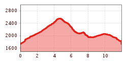
Silz / Stubaier Alpen
Difficulty ratings: medium
Route length: 12.0 km
Duration: 7:30 h

Wetterkreuzkogel - Bielefelder Hütte

Tour information

  • Requirement: medium
  • Length: 12.0 km
  • Duration: 7:30 h
  • Elevation uphill:1,044 hm
Highest point2,591 m

Features

  • Circular route

Description

This hike leads past the ruins of the Oberer Issalm mountain hut, through the romantic wilderness of the Wörge Valley and up to Wetterkreuzkogel peak. From there, continue north-west towards the Bielefelder Hütte mountain hut and back via the Balbach Sennhütte mountain hut.

More tours in the surrounding area

Newsletter

The mountain is calling? So does our newsletter!

In our monthly newsletter we reveal the best holiday tips for Tyrol.