Hut Rheinland-Pfalz-Biwak

Mainz

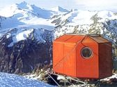
The Rheinland-Pfalz-Biwak (3,247 metres) is an emergency refuge high in the Ötztal Alps at the foot of the Wassertalkogel mountain, on the Mainz High Trail.

Information

Altitude

3,247 m

Mountain range

Ötztal Alps

Facilities

  • Self catering hut

Suitable for:

  • High-altitude hikes

Coordinates

  • Geographic length:10.904722222222
  • Geographic width:46.966944444444
  • UTM (east):5203254
  • UTM (east):644905
  • Reference Meridian:
Source: Alpenverein

Description

Emergency refuge between the Rüsselsheimer Hütte and the Braunschweiger Hütte
German Alpine Club, Mainz Division

With its orange, octagonal design, the Rheinland-Pfalz-Biwak is certainly eye-catching. It is an emergency refuge high in the Ötztal Alps providing shelter for walkers and hikers caught in bad weather or suffering some other misfortune on the Mainz High Trail. It connects two other huts, the Rüsselsheimer Hütte and the Braunschweiger Hütte, and is located near five 3,000-metre mountains and three glaciers. The terrain is alpine and challenging, so visitors must be sure-footed and should be able to deal with rock climbing sections up to grade II. A good sense of direction is also important. The reward for all that hard work is a wonderful vista taking in the Pitztal Valley and the Ötztal Valley, including the Kaunergrat ridge and the Kaunergrathütte hut as well as the Main Stubai Ridge. Amenities in the hut are basic, with a cooking area and nine sleeping places. Water can be drawn from a nearby ice field. Food must be brought by visitors themselves. The hut is locked (key available from the Alpine Club).

How to get to the hut

From Plangeroß / car park of the Rüsselsheimer Hütte in 7.5 hours, from Mittelberg in 7 hours, from car park at Rettenbachferner glacier in 4.5 hours

Walks and hikes in the area (walking time to summit)

Weißmaurachjoch (2,953 metres), 3 hours, difficult
Pitztaler Jöchl (2,996 metres), 4 hours, difficult
Emergency descent to Mandarfen (1,690 metres), 3.5 hours

Further huts in the area, long-distance hiking trails

Braunschweiger Hütte (via Pitztaler Jöchl), 4.5 hours
Rüsselsheimer Hütte (via Weißmaurachjoch), 5 hours

The Rheinland-Pfalz-Biwak is located on the Mainz High Trail, a challenging long-distance hiking trail, and on Stage 18 of the Ötztal Trek.

Getting here

Nearby huts

  • Solsteinhaus

    Place:Karwendel Mountains
    :1,805 m
    :Suitable formountain hikingRock climbingMountain bike
  • Karlsbader Hütte

    Place:Gailtal Alps
    :2,260 m
    :Suitable formountain hikingRock climbingMountain bike
  • Kaunergrathütte

    Place:Ötztal Alps
    :2,817 m
    :Suitable formountain hikingHigh-altitude hikesRock climbingSki touring
  • Straubinger Haus

    Place:Chiemgau Alps
    :1,558 m
    :Suitable formountain hikingMountain bikeSki touring
  • Stüdlhütte

    Place:Glockner Mountains
    :2,801 m
    :Suitable forHigh-altitude hikesRock climbingSki touring
  • Sudetendeutsche Hütte

    Place:Granatspitz Mountains
    :2,650 m
    :Suitable formountain hikingHigh-altitude hikesRock climbingSki touring
  • Kölner Haus

    Place:Samnaun Mountains
    :1,965 m
    :Suitable foralpine skiingmountain hikingHigh-altitude hikesRock climbingMountain bikeSki touring
  • Lamsenjochhütte

    Place:Karwendel Mountains
    :1,953 m
    :Suitable formountain hikingRock climbing
  • Landshuter-Europa-Hütte

    Place:Zillertal Alps
    :2,693 m
    :Suitable formountain hikingHigh-altitude hikesSki touring
  • Langtalereckhütte

    Place:Ötztal Alps
    :2,450 m
    :Suitable formountain hikingHigh-altitude hikescross country skiingSki touring
  • Leutkircher Hütte

    Place:Lechtal Alps
    :2,251 m
    :Suitable formountain hikingSki touring
  • Lienzer Hütte

    :1,977 m
    :Suitable formountain hikingHigh-altitude hikesRock climbingMountain bike
  • Vernagthütte

    Place:Ötztal Alps
    :2,755 m
    :Suitable formountain hikingHigh-altitude hikesRock climbingSki touring
  • Geraer Hütte

    Place:Zillertal Alps
    :2,324 m
    :Suitable formountain hikingHigh-altitude hikesRock climbingSki touring
  • Meißner Haus

    Place:Tux Alps
    :1,720 m
    :Suitable formountain hikingMountain bikeSki touring
  • Westfalenhaus

    Place:Stubai Alps
    :2,273 m
    :Suitable formountain hikingHigh-altitude hikesSki touring
  • Glorer Hütte

    Place:Glockner Mountains
    :2,642 m
    :Suitable formountain hikingHigh-altitude hikes
  • Winnebachseehütte

    Place:Stubai Alps
    :2,372 m
    :Suitable formountain hikingRock climbingSki touring
  • Glungezerhütte

    Place:Tux Alps
    :2,610 m
    :Suitable formountain hikingHigh-altitude hikesRock climbingSki touring
Newsletter

The mountain is calling? So does our newsletter!

In our monthly newsletter we reveal the best holiday tips for Tyrol.