
Difficulty:
medium
Length:
15.4 km
Duration:
5:30 h
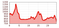
Elevation uphill:
968 m
Impressive panoramic view of the Reutte valley basin.
The Lechweg trail starts in Wängle and first takes you along the high panoramic trail before a path leads up to the Costarieskapelle chapel. From here, there is an impressive panoramic view of the Reutte valley basin. The route then continues towards Frauensee and down to Hinterbichl, where the Lech is crossed to continue to Pflach. On the last section of the route, you leave the Lech and hike along forest and woodland paths to Alpsee, which is located on Bavarian soil. From there, the route continues to the Calvary and down to the Lech Falls. Experience the beauty of nature and the cultural sights along the way.


.jpg")

