Dolomitenlauf 2022Opening hours: closed Difficulty: medium Length: 21.0 km Elevation uphill: 230 m : Style: Skating, Classic Go to Cross-country skiing trailMore about Dolomitenlauf 2022
Gornerwald Trail No. 139Opening hours: closed Difficulty: difficult Length: 2.3 km Duration: 0:30 h Go to biketourMore about Gornerwald Trail No. 139
High and sacred – Stage 01 from Lavant to St. KorbinianMore InformationMore about High and sacred – Stage 01 from Lavant to St. Korbinian
High and sacred – Stage 08 from Obermauern to KalsMore InformationMore about High and sacred – Stage 08 from Obermauern to Kals
High and sacred – Stage 09 from Kals to HeiligenblutMore InformationMore about High and sacred – Stage 09 from Kals to Heiligenblut
High and sacred – Stage 04 from St. Oswald to InnichenMore InformationMore about High and sacred – Stage 04 from St. Oswald to Innichen
High and sacred – Stage 06 from Kalkstein to St. Jakob im DefereggentalMore InformationMore about High and sacred – Stage 06 from Kalkstein to St. Jakob im Defereggental
High and sacred – Stage 07 from St. Jakob im Defereggental to ObermauernMore InformationMore about High and sacred – Stage 07 from St. Jakob im Defereggental to Obermauern
Adlertrail No. 138Opening hours: closed Difficulty: medium Length: 3.7 km Duration: 0:20 h Go to biketourMore about Adlertrail No. 138
Alban Lakata Trail No. 142Opening hours: open Difficulty: medium Length: 2.0 km Duration: 0:20 h Elevation uphill: 10 m Go to biketourMore about Alban Lakata Trail No. 142
Filmoor-Standschützenhütte über das LeitertalDifficulty: medium Length: 8.5 km Duration: 5:30 h Elevation uphill: 900 m See trailMore about Filmoor-Standschützenhütte über das Leitertal
Peter Sagan Trail No. 141Opening hours: open Difficulty: medium Length: 5.0 km Duration: 0:30 h Elevation uphill: 90 m Go to biketourMore about Peter Sagan Trail No. 141
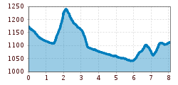
High and sacred – an Alpine pilgrim trail through East Tyrol, South Tyrol and Upper CarinthiaDifficulty: medium Length: 194.0 km Duration: 65:00 h Elevation uphill: 11,200 m See trailMore about High and sacred – an Alpine pilgrim trail through East Tyrol, South Tyrol and Upper Carinthia
Böses WeiblDifficulty: difficult Length: 14.1 km Duration: 8:00 h Elevation uphill: 1,193 m See trailMore about Böses Weibl
Höfe Trail stage 1: Sillian - KartitschMore InformationMore about Höfe Trail stage 1: Sillian - Kartitsch
Unterfeldloipe Prägraten (illuminated)Opening hours: closed Difficulty: easy Length: 3.3 km Elevation uphill: 36 m : Style: Skating, Classic Go to Cross-country skiing trailMore about Unterfeldloipe Prägraten (illuminated)
DolomitenloipeOpening hours: closed Difficulty: medium Length: 7.5 km Elevation uphill: 10 m : Style: Skating, Classic Go to Cross-country skiing trailMore about Dolomitenloipe
Blusenrunde PrägratenOpening hours: closed Difficulty: easy Length: 1.4 km Elevation uphill: 13 m : Style: Skating, Classic Go to Cross-country skiing trailMore about Blusenrunde Prägraten
Winter walking at the Dorfberg in East TirolOpening hours: closed Difficulty: difficult Length: 12.0 km Duration: 5:00 h Elevation uphill: 680 m Go to winter hikeMore about Winter walking at the Dorfberg in East Tirol
RotenkogelDifficulty: difficult Length: 3.9 km Duration: 3:00 h Elevation uphill: 383 m See trailMore about Rotenkogel
Oberseitsee - Seespitze 3.021 mDifficulty: difficult Length: 14.4 km Duration: 8:30 h Elevation uphill: 1,310 m See trailMore about Oberseitsee - Seespitze 3.021 m
Schober trekDifficulty: medium Length: 33.0 km Duration: 30:00 h Elevation uphill: 3,200 m See trailMore about Schober trek
Umbal waterfalls nature force trailDifficulty: easy Length: 5.8 km Duration: 2:30 h Elevation uphill: 250 m See trailMore about Umbal waterfalls nature force trail
Golzentipp 2.317 mDifficulty: easy Length: 5.6 km Duration: 2:00 h Elevation uphill: 267 m See trailMore about Golzentipp 2.317 m
Give feedback for a chance to win a special holiday experience!Click here for the surveyClick here for the survey


")

.jpg")
.jpg")


