Mountain hikes Wanderung zur Stüdlhütte

Kals am Großglockner / Glocknergruppe
Difficulty ratings: medium
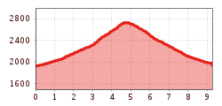
Route length: 9.3 km
Duration: 5:30 h

Wanderung zur Stüdlhütte

Tour information

  • Requirement: medium
  • Length: 9.3 km
  • Duration: 5:30 h
  • Elevation uphill:862 hm
  • Elevation downhill:857 hm
Highest point2,802 m

Starting point

Parkplatz Glocknerwinkel

Finishing point

Parkplatz Glocknerwinkel
  • Fitness level 3 / 6
  • Technique 2 / 6

Best time of year

  • January
  • February
  • March
  • April
  • May
  • June
  • July
  • August
  • September
  • October
  • November
  • December

Description

Ascent via Kalser Glocknerstrasse to the Glocknerwinkel car park (toll fee).

Permanently viewing the Grossglockner, the AV Weg 702 B leads from the Lucknerhaus for about 1 hour through the varied Koednitztal Valley (opportunities to observe marmots, chamois and ibex) to the Lucknerhuette and on the same route to the "Viehboeden" (junction Johann-Stuedl-Weg) and to the Stuedlhuette on the Fanot-Scharte.

The Stuedlhuette is the ideal and most frequently used starting point for climbing the Grossglockner.

More tours in the surrounding area

Newsletter

The mountain is calling? So does our newsletter!

In our monthly newsletter we reveal the best holiday tips for Tyrol.