Großer MutzkopfDifficulty: easy Length: 10.3 km Duration: 4:00 h Elevation uphill: 507 m See trailMore about Großer Mutzkopf
Nauders mountain trailDifficulty: medium Length: 18.0 km Duration: 7:00 h Elevation uphill: 407 m See trailMore about Nauders mountain trail
Schwarzer and Grüner SeeDifficulty: easy Length: 8.3 km Duration: 4:30 h Elevation uphill: 368 m See trailMore about Schwarzer and Grüner See
Rundwanderung FrudigerDifficulty: medium Length: 13.5 km Duration: 5:00 h Elevation uphill: 588 m See trailMore about Rundwanderung Frudiger
Klammsteig - GreitOpening hours: closed Difficulty: medium Length: 8.8 km Duration: 3:00 h Elevation uphill: 469 m See trailMore about Klammsteig - Greit
Wallfahrtsweg Kauns (1.050 m) - Kaltenbrunn (1.287 m)Difficulty: easy Length: 9.2 km Duration: 3:30 h Elevation uphill: 290 m See trailMore about Wallfahrtsweg Kauns (1.050 m) - Kaltenbrunn (1.287 m)
Talwanderweg KaunertalDifficulty: easy Duration: 2:30 h Elevation uphill: 295 m See trailMore about Talwanderweg Kaunertal
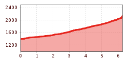
Ötztal Trek Stage 15Difficulty: difficult Length: 6.5 km Duration: 2:30 h Elevation uphill: 332 m See trailMore about Ötztal Trek Stage 15
VerpeilschluchtDifficulty: medium Duration: 3:00 h Elevation uphill: 386 m See trailMore about Verpeilschlucht
Give feedback for a chance to win a special holiday experience!Click here for the surveyClick here for the survey
.jpg")
.jpg")
.jpg")
.jpg")
.jpg")
.jpg")


