Mountain hikes Um den Ramsbach

Walchsee / Chiemgauer Alpen
Difficulty ratings: easy
Route length: 2.8 km
Duration: 1:00 h

Weg Nr. 37

Tour information

  • Requirement: easy
  • Length: 2.8 km
  • Duration: 1:00 h
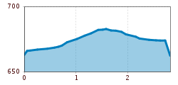
  • Elevation uphill:35 hm
  • Elevation downhill:35 hm
Highest point694 m

Starting point

Infobüro Walchsee

Finishing point

Infobüro Walchsee
  • Fitness level 1 / 6
  • Technique 1 / 6

Features

  • Circular route
  • Suitable for families
  • suitable for pushchairs

Best time of year

  • January
  • February
  • March
  • April
  • May
  • June
  • July
  • August
  • September
  • October
  • November
  • December

Trail condition

gravel, path

Equipment

appropriate clothing, sturdy footwear, backpack, rain protection, possibly hiking poles, mobile phone, sunscreen, snack (breakfast) and drinks, possibly photo camera

Description

From the village center, at Café Ilgerhof, in northern direction at Biosennerei over to the Ramsbach bridge. Immediately after the bridge turn right, follow the footpath along Ramsbach to Winkl. Then right along the driveway to Walchsee.

Getting here

More tours in the surrounding area

Newsletter

The mountain is calling? So does our newsletter!

In our monthly newsletter we reveal the best holiday tips for Tyrol.