Mountain hikes Tux-Lanersbach - Finkenberg via Lachtalscharte
Tux/Hintertux im Zillertal / Tuxer Alpen
Difficulty ratings: difficult
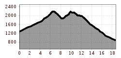
Route length: 18.7 km
Duration: 8:30 h

Tux-Lanersbach - Finkenberg via Lachtalscharte

Tour information

  • Requirement: difficult
  • Length: 18.7 km
  • Duration: 8:30 h
  • Elevation uphill:1,260 hm
  • Elevation downhill:1,650 hm
Highest point2,200 m

Starting point

Tux-Lanersbach Hinterangerbrücke

Finishing point

Finkenberg Dornau

Best time of year

  • January
  • February
  • March
  • April
  • May
  • June
  • July
  • August
  • September
  • October
  • November
  • December

Trail condition

Bergweg, Bergpfad, Schotterweg Lachtalscharte to Gamshütte: head for heights and surefootedness required!

Description

From Tux-Lanersbach on the gravel road (path 28) to the Höllensteinhütte. Ascent to the "Am Flach" (Tettensjoch/Kreuzjoch), from there turn right to the Elsalm and then on the AV trail 534 steeply ascending to the Lachtalscharte. Now crossing partly very steep slopes to the Gamshütte. Direct descent on the AV trail 534 to the Brunnhaus district in Finkenberg. Return by public bus.

TIP: From Tux-Lanersbach, the demanding trail 20 leads directly to the Kreuzjoch, walking time 2.5 h; entry: over the Hinteranger bridge and uphill, left shortly before house no. 509.
 

More tours in the surrounding area

Newsletter

The mountain is calling? So does our newsletter!

In our monthly newsletter we reveal the best holiday tips for Tyrol.