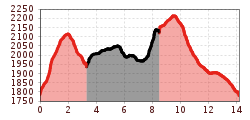
The Sellrainer Höhenwanderweg trail

The Sellraintaler Höhenweg is a high altitude trail that leads along the two-thousand-metre contour line from the Zirmbachalm mountain hut, which lies between Haggen and Kühtai, to the Rosskogelhütte mountain hut on Rangger Köpfel mountain in Oberperfuss.
The trail is well-signposted and starts 300 metres east of the Zirmbachalm, initially leading steeply uphill to the terraced pastures on Sonnberg mountain. From there, it continues at a moderate incline high above the Sellrain Valley, passing through the alpine pastures of the Haggen and Peider Sonnberg, traversing the slopes of the Koflerspitze and Weißstein to just below the Rosskogel and then finally continuing from Kögele to the Rosskogelhütte mountain hut. From there, you can take the gondola down to Oberperfuss for a relaxing trip back into the valley. From the Höhenweg trail, it is possible to make a detour up to the summit of Seejoch, Weißstein or Rosskogel.
There are routes back to the valley in various places along the way: via the Sonnbergalm to St. Sigmund, along the Heuriesenweg trail to Gries im Sellrain or via St. Quirin to Sellrain.