Mountain hikes Sattelwaldweg

closed
St. Christoph am Arlberg / Lechtaler Alpen
Difficulty ratings: medium
Route length: 13.8 km
Duration: 4:30 h

Sattelwaldweg

Tour information

  • Requirement: medium
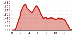
  • Length: 13.8 km
  • Duration: 4:30 h
  • Elevation uphill:560 hm
Highest point1,644 m

Starting point

Arlberg WellCom

Finishing point

Arlberg WellCom

Features

  • Circular route

Trail condition

Waldweg

Equipment

Festes Schuhwerk, wetterabhängig Regenschutz/ Sonnenschutz, eventuell Stöcke

Description

From Arlberg WellCom, head west to the Rendlbahn lift. Directly after the pedestrian bridge, follow the signs for “Moostalweg”, passing by the Bifangalm, and on to the dam. Take the catwalk and on the other side of the valley turn right and follow the forest road. This path winds through switchbacks until it reaches a clearing.
From there, it is an easy climb down to the Wagner Hut, and then a short ascent to the hiking trail and back to St. Anton.

More tours in the surrounding area

Newsletter

The mountain is calling? So does our newsletter!

In our monthly newsletter we reveal the best holiday tips for Tyrol.