Description
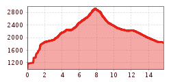
Take the Medrigjochbahn to get to the mountain station at 1.800 m. From here, the ascent is initially flat until just before the Versingbahn, from where a narrow path snakes up to Ascherhütte, with the Lechtal Alps always in your line of sight. From Ascherhütte, route no. 711 proceeds via the Spinnscharte up to the Rotpleiskopf at 2.933 m. The final section of the route requires sure-footedness and a head for heights. Return section: the descent proceeds via the Kübelgrubenscharte back to Ascherhütte. Here you can either opt to take the same route back or proceed via the path to get to Medrigjochbahn mountain station, which takes you back down into the valley again. Please note the cable car operating hours for your return journey.
.jpg")


.jpg")
.jpg")

.jpg")
.jpg")


