Description
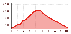
Starting from the cable car station in See the route heads past Hotel Mallaun to the Ahle crossroads and here continues up via the hamlets of Klaus and Neder. Here head down into the valley via a peaceful meadow and forest trail to Habigen.At the hiking noticeboard in Habigen the route proceeds left, up to the forest trail. Here the route heads left out of the valley until the next branch-off. You then hike through the Flathtal to the signposted fork in the road to Stielalpe – and the non-managed Pferdealm, which promises a breath-taking panorama view. After a brief break continue to Istalanztal and then hike down the valley along Istalanzbach until you reach the forest trail. Follow the footpath markers here until you cross the next forest road. The route then heads past Hubertuskapelle, back to See.

.jpg")
.jpg")
.jpg")


.jpg")

.jpg")


