Mountain hikes Rossfallalpe

closed
St. Christoph am Arlberg / Lechtaler Alpen
Difficulty ratings: easy
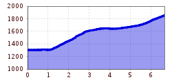
Route length: 6.6 km
Duration: 2:30 h

Rossfallalpe

Tour information

  • Requirement: easy
  • Length: 6.6 km
  • Duration: 2:30 h
  • Elevation uphill:568 hm
Highest point1,856 m

Starting point

Arlberg WellCom

Finishing point

Rossfallalpe

Best time of year

  • January
  • February
  • March
  • April
  • May
  • June
  • July
  • August
  • September
  • October
  • November
  • December

Equipment

Good walking boots, poles and drinks/snacks, rain jacket, sun protection

Description

From the Arlberg WellCom in a westerly direction to the Rendlbahn, immediately after over the footbridge, follow the signs to the Moostalweg, past the Bifang-Alm along trail 32, after the dam wall turn left and follow the trail up a steep incline until it joins the Moostalfahrweg. From here, continue right to the Rossfallalpe (St). Take the same path back to the starting point (approx. 2 hours).

Variant: Up with the Rendlbahn and then down into the Moostal valley.

More tours in the surrounding area

Newsletter

The mountain is calling? So does our newsletter!

In our monthly newsletter we reveal the best holiday tips for Tyrol.