Mountain hikes Prutz via Römerweg

Ladis / Samnaungruppe
Difficulty ratings: easy
Route length: 1.7 km
Duration: 1:00 h

Prutz via Römerweg

Tour information

  • Requirement: easy
  • Length: 1.7 km
  • Duration: 1:00 h
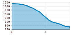
  • Elevation uphill:12 hm
  • Elevation downhill:336 hm
Highest point1,191 m

Starting point

Castle pond in Ladis

Finishing point

Prutz

Description

Go towards Obladis, but immediately after the first house go right onto the Hohlweg trail down to the tennis court. At the crossing which comes soon after, either go right on the trail to the Felsenburg, which becomes quite flat, and then down to the left on the asphalted road to the Innbrücke bridge or go straight ahead to the vehicle road to the Asterhöfe.


More tours in the surrounding area

Newsletter

The mountain is calling? So does our newsletter!

In our monthly newsletter we reveal the best holiday tips for Tyrol.