Path of the water sources

Mieders / Stubaier Alpen
Difficulty ratings: easy
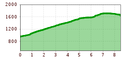
Route length: 8.4 km
Duration: 3:05 h

Path of the water sources

Tour information

  • Requirement: easy
  • Length: 8.4 km
  • Duration: 3:05 h
  • Elevation uphill:767 hm
  • Elevation downhill:78 hm
Highest point1,723 m

Best time of year

  • January
  • February
  • March
  • April
  • May
  • June
  • July
  • August
  • September
  • October
  • November
  • December

Description

Water is origin and life

From the valley station of the Serlesbahnen in Mieders, it goes along the fountains, springs and stations, past the Ochsenhütte to the pilgrimage site of Maria Waldrast. Alternatively, you can start from the mountain station.

Stations

  • Kaspar-Stauder-Path
  • Marienstein
  • Besser- Fountain
  • Krinne (Flume )
  • Hirschlacke
  • Maria Waldrast
  • Zangger Fountain (zanggen = ziehen = draw)
  • Evangeldaxe (Daxe = Tannenzweig = fir branch)
  • Goldenes Brünnl
  • Klaushof Fountain

More tours in the surrounding area

Newsletter

The mountain is calling? So does our newsletter!

In our monthly newsletter we reveal the best holiday tips for Tyrol.