Panorama-Tour im Gelände des ehemaligen Magnesitwerks von Tux

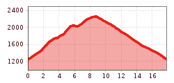
In Tux-Vorderlanersbach turn right at hotel Tuxerhof (house no. 80). Follow the road in direction Schöneben uphill and turn right at the first cross-road, carrying on up over the bridge (path no. 55), past the Stockbauer farm (house no. 40) and on to the Schrofenalm. Now make your way up on path no. 57 to the Penkenjoch. Turn left on the broad path (no. 57) leading to the Wanglalm and then left again on the somewhat broader path (no. 55) as far as the Lämmerbichl restaurant, thence down to Tux-Vorderlanersbach. Superb panoramic high-level path from Penken to the Lämmerbichlalm commanding a wonderful view onto the Ziller Valley Alps and the main Tux ridge. From Finkenberg it is possible to reach the Penkenjoch (2,095 m) via the cable railway.