
Opening hours:
closed
Difficulty:
easy
Length:
573 m
Duration:
0:20 h
Elevation uphill:
12 m
Lawensalpe from the Komperdell
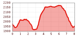
From the Komperdell top station (S104) to the Kölner Haus (S103). Get there on the trail to the Lausbachbrücke bridge, past the Cervosa Alm on a vehicle track then up to the crossing (S279). On the narrow Truiensteig path no. 5b (sure-footedness required) to the Leitle Kreuzchen (S300). On the vehicle track, go down to the Lawensalpe (S297, alpine cow pasture of Ladis). From there on trail no. 30b over the stairway ascent to the signpost (S290) and continue to the Böderhütte (S286). At the Böderweg trail no. 30 hike to the Lazid Kreuzchen (S280) and from there down again on a vehicle track back to the point of departure.


