Mountain hikes Klausenbergrunde

Kirchberg in Tirol / Kitzbüheler Alpen
Difficulty ratings: easy
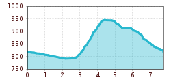
Route length: 7.8 km
Duration: 1:30 h

For the whole family!

Tour information

  • Requirement: easy
  • Length: 7.8 km
  • Duration: 1:30 h
  • Elevation uphill:187 hm
  • Elevation downhill:190 hm
Highest point964 m

Starting point

center Kirchberg

Finishing point

center Kirchberg
  • Fitness level 2 / 6
  • Technique 2 / 6

Features

  • Circular route
  • Suitable for families

Best time of year

  • January
  • February
  • March
  • April
  • May
  • June
  • July
  • August
  • September
  • October
  • November
  • December

Trail condition

asphalt, gravel road, wood path

Equipment

hiking shoes, weather protection, drink, first aid kit

Description

We start at the information office in Kirchberg, cross the village square, walk into Reithergasse and from there over the bridge to arena365 and along the river Ache in the direction of Kitzbühel. In the Klausen district, we turn right towards the Schwedenkapelle chapel. Pass the Schwedenkapelle chapel and take the forest road up the Klausenberg. The ascent continues along a forest path and past the Staudachstube inn. Up to the Gauxerbauer and via the Tannenweg back to the centre of Kirchberg.


Getting here

  • Arrival by public transport

    bus stop Gemeindeamt Kirchberg
    railway station Kirchberg in Tirol

  • Parking

    Parkgarage Pöllmühle

More tours in the surrounding area

Newsletter

The mountain is calling? So does our newsletter!

In our monthly newsletter we reveal the best holiday tips for Tyrol.