Starting from the Pfeishütte, the fourth stage of the Karwendel Höhenweg trail sees you head across the Stempeljoch before reaching the Bettelwurfhütte. On the way, you follow a trail created by the ‘Wilde Bande’ mountaineers’ group that was founded in 1878. This stage takes you through the mountain pines and Alpine pastures of the Pfeis area, rewarding you with breath-taking views over the craggy Karwendel mountains and down into the Halltal valley.

Mountain path.
All current information about trail closures in the Seefeld region can be found here.
Have you discovered a spot that needs maintenance or repair? Fill out the 'Report a Hazard' form and let us know where work is needed in the region.
Good footwear, functional clothing, a hiking backpack, water, provisions, alpine experience, and surefootedness are necessary for this tour!
Additionally, a hiking map or GPS, a first aid kit, sun protection, trekking poles, and an emergency blanket are recommended.
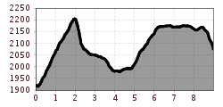
The fourth stage of the Karwendel High Trail begins at the Pfeishütte and follows Trail 221 (Via Alpina) eastward up to the Stempeljoch ridge between the Pfeiser Spitze and the Kleine Stempeljochspitze mountains. Once you have reached the ridge between the Pfeiser Spitze and the Stempeljochspitze at an elevation of 2215 metres, you must then make a steep descent as the trail leads across a gravel field.
CAUTION: in early summer, the Stempelreise gravel field may still feature a very large amount of old snow that is extremely hard and frozen in the mornings (risk of falling: Snowline Spikes and sticks provide optimum protection)!
After a descent featuring a difference in elevation of around 140 metres, you turn left on to the Wilde-Bande-Steig trail. Fields with old snow are also a common sight at this intersection. The trail begins by leading you below the east and south faces of the Stempeljochspitze, the Roßkopf, the Großer Lafatscher and the Kleiner Lafatscher mountains, with very little variation in elevation as you head towards the Lafatscher Joch. Approaching the Lafatscher Joch (2081 m), you have to complete another ascent with an elevation gain of around 80 metres. As of this point, trail 222 (= Via Alpina) heads east with a gentle incline as it passes through the Kleines Speckkar and Großes Speckkar cirques. The final part of the journey before you reach the Bettelwurfhütte hut is characterised by panoramic views over the Halltal and Inntal valleys, with the mountain hut sitting atop the south face of the Kleiner Bettelwurf mountain like an eagle’s nest.
Summits along the way:
If you still have time and stamina, you can take the following peaks on this stage by making a detour:
• Kreuzjöchl (2158 m); ascent: +1 h (red mountain trail)
• Pfeiserspitz (2347 m); ascent: +1.5 h (black mountain trail)
• Stempeljochspitze (2529 m); ascent: +2 h (red mountain trail)